Preparations for Next Moonwalk Simulations Underway (and Underwater)
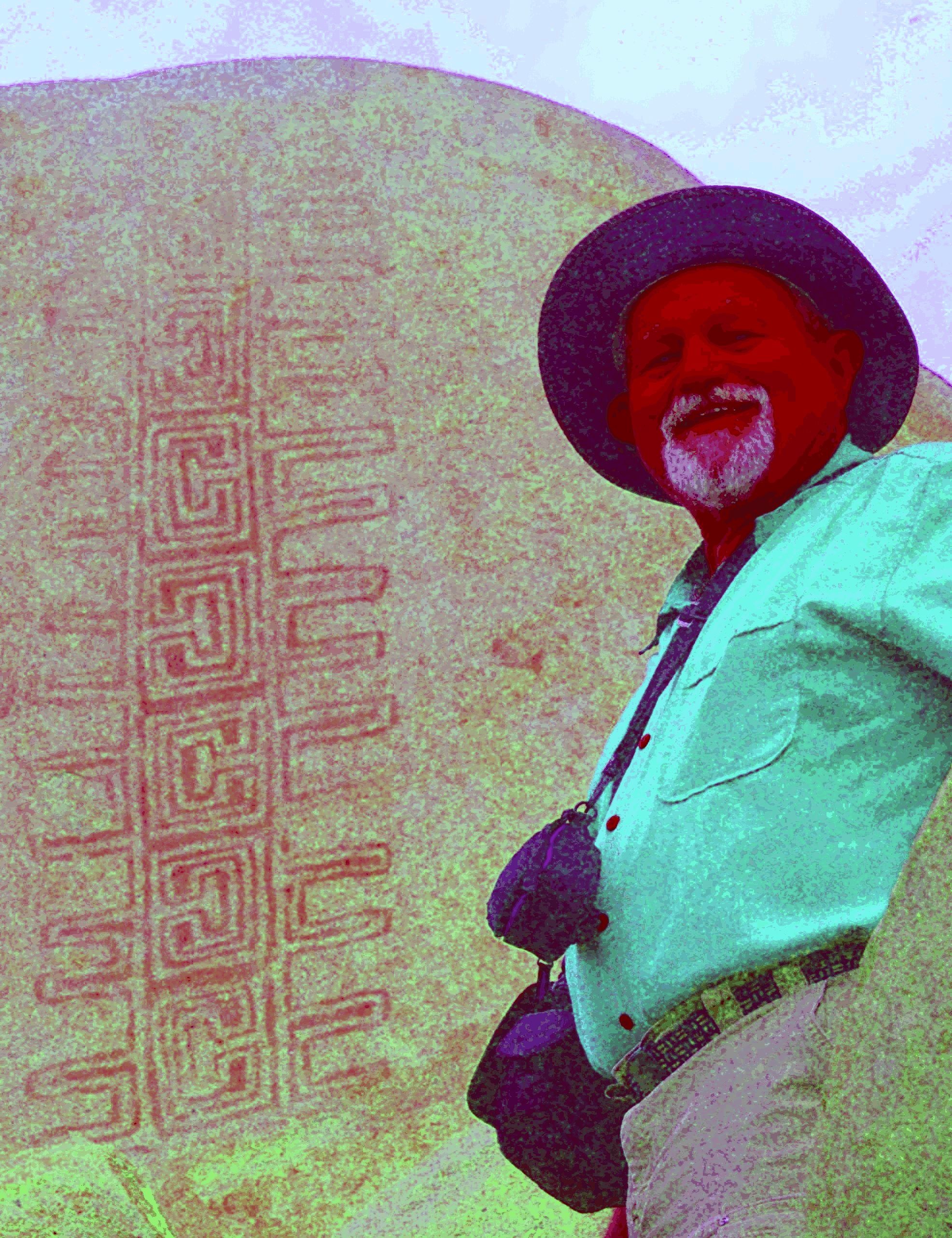
Jon Harman poses in front of an example of the Rancho Bernardo style of Native American artwork that’s barely visible until Dstretch is applied.
Credit: Jon Harman
High in the central tower in the ancient Cambodian temple of Angkor Wat, paintings depict horseback riders and a traditional musical ensemble. Thousands of visitors pass these images daily without noticing, because they’re faded to the point of invisibility.
They were discovered between 2010 and 2012, along with about 200 other paintings throughout the complex, by an archaeologist using a method conceived at NASA’s Jet Propulsion Laboratory in Southern California.
The technique, known as decorrelation stretch, heightens contrasts in digital imagery, making features easier to spot. It is especially popular for studying ancient rock art, partly due to the chance intersection of one man’s hobby with his professional background.
Around 2005, rock art enthusiast Jon Harman saw NASA images depicting the Martian surface with and without the application of decorrelation stretch. Seeing how much detail the technique revealed, Harman, now retired in Pacifica, California, understood the implication for studying ancient, faded images.
He also worked in medical imaging. “I Googled it and found a NASA paper that explained how to do the algorithm,” he said. “I knew from my medical imaging experience that I could do it, so I did.”
The paper was written in 1996 by Ronald Alley, a JPL employee developing applications for the Advanced Spaceborne Thermal Emission and Reflection Radiometer (ASTER), a Japanese imaging instrument on NASA’s Terra satellite. One of Alley’s former supervisors at JPL had coinvented decorrelation stretch, and Alley had recognized its potential for gleaning information from ASTER imagery.
Harman made his plug-in for use with ImageJ, an open-source program developed by the National Institutes of Health.
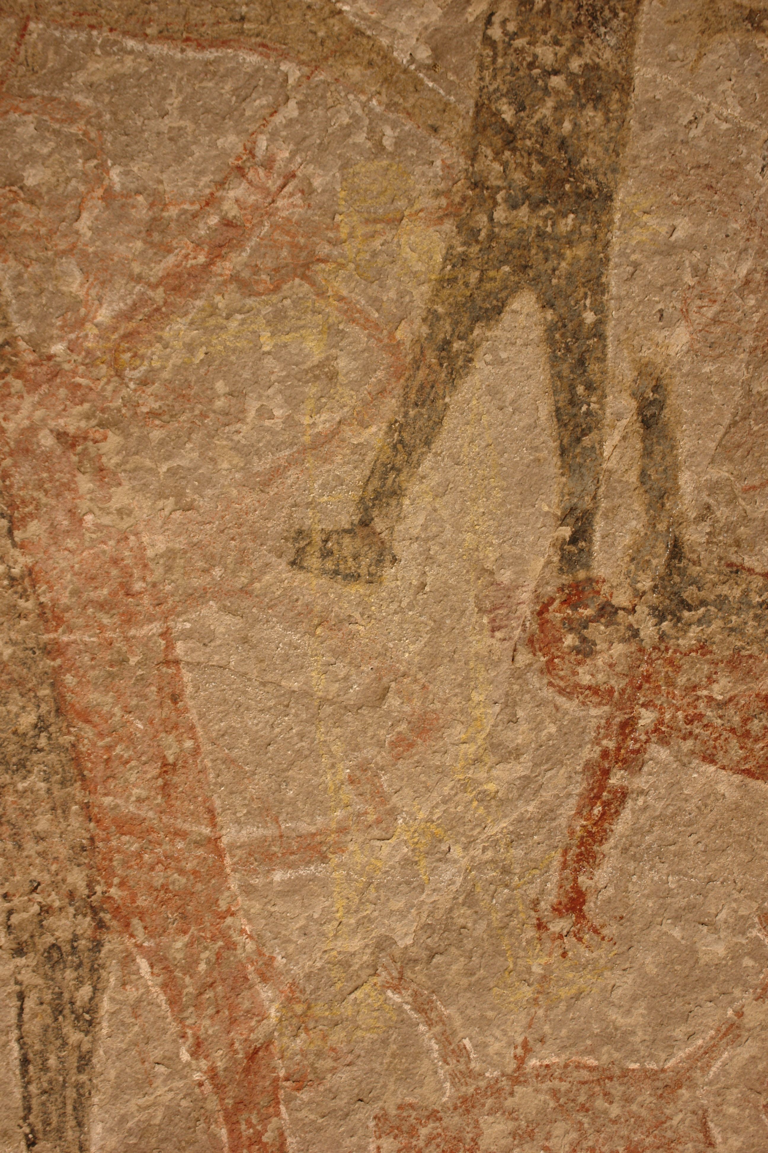
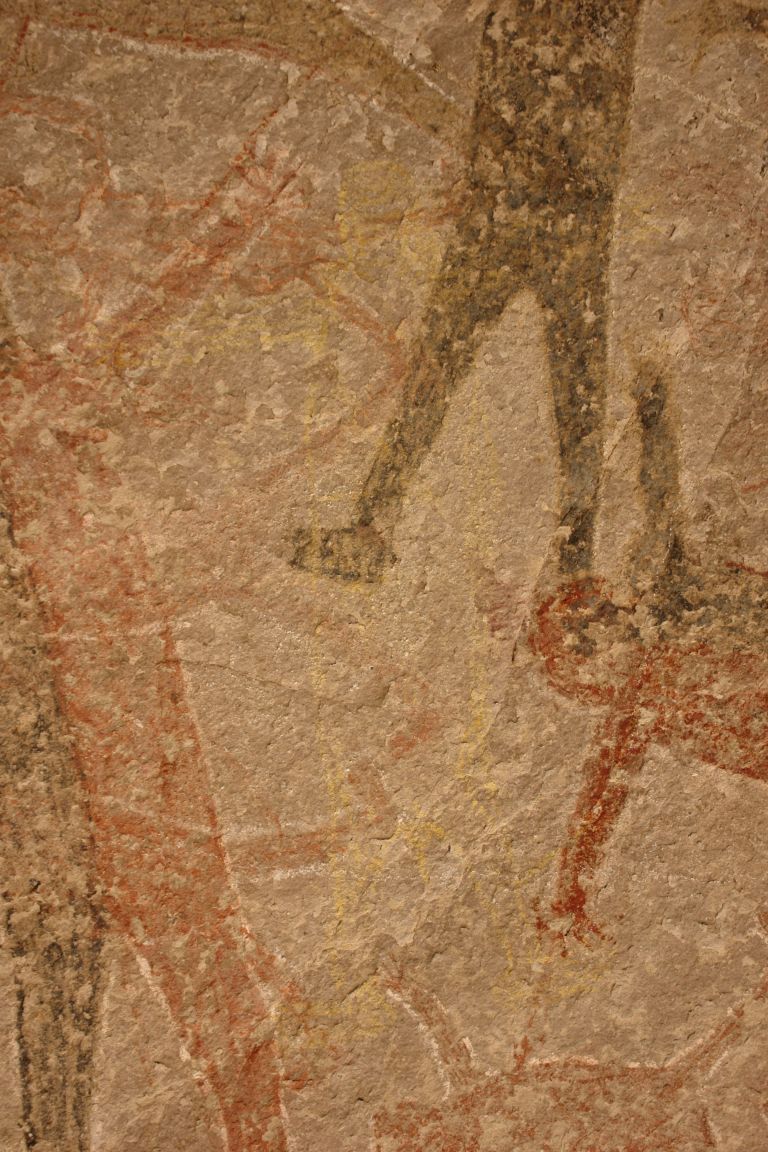
before
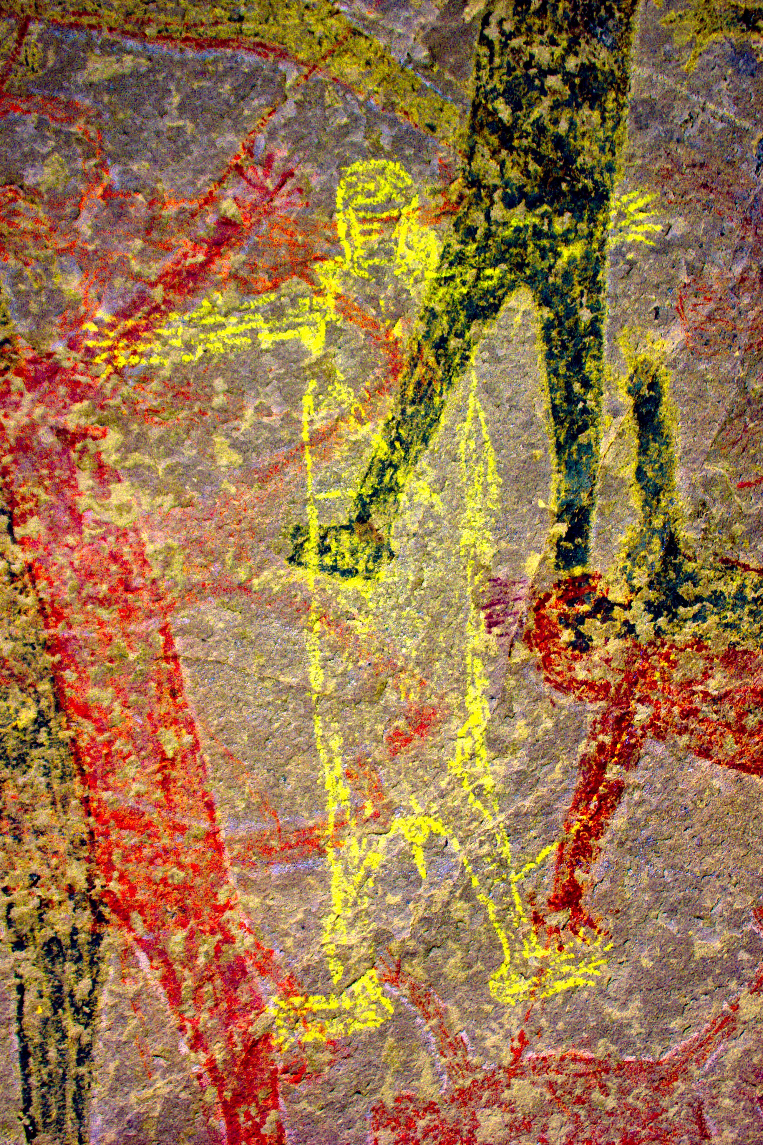
after
before
after
Before and After
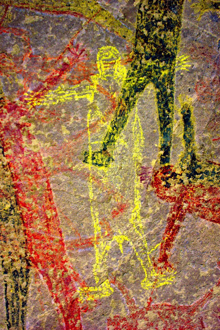
Dstretch applied to Cave of San Borjitas in Baja California, Mexico
As Jon Harman was developing the Dstretch plug-in, he applied it to this image from the Cave of San Borjitas in Baja California, Mexico. When the yellow figure appeared in the middle of the picture, he knew he had something useful. Credit: Jon Harman
He said he fulfills about 200 requests for Dstretch per year. Around 2010, he also created smartphone apps that use a shortcut to mimic decorrelation stretch. The apps have been downloaded thousands of times, and papers have been published describing Dstretch’s usefulness in archaeology.
It has been used to spot and clarify imagery at ancient sites under a cliff in Norway, in an Egyptian tomb, at a park in Canada, and in many other locations. It has also helped archaeologists find buried remains of ancient Greek buildings and examine tattoos on mummified human remains, among its non-rock-art applications.
Harman said he was not surprised Dstretch found wide use in the rock art community. “But I’ve been surprised by a lot of the different applications people have found. So that’s been cool.”
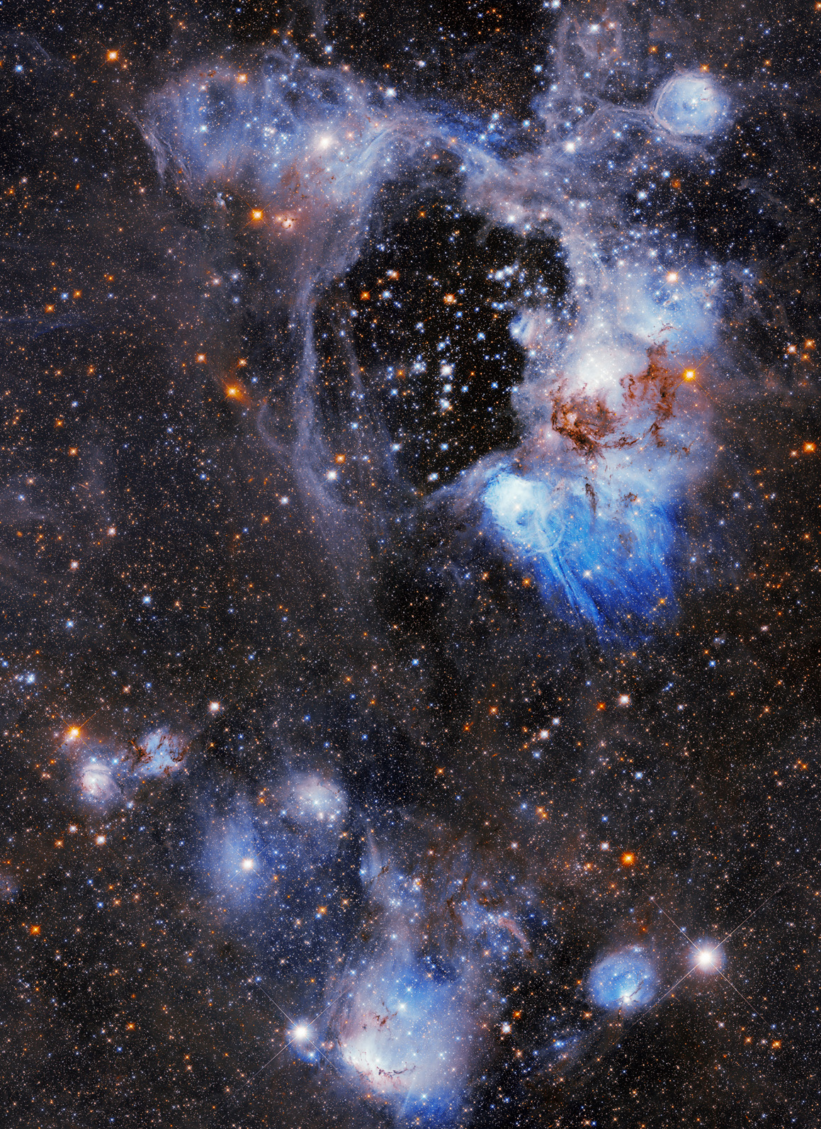
NASA’s Hubble Space Telescope captures a photogenic nebula, N44, in the Large Magellanic Cloud in this Sept. 3, 2026, image. N44 is dominated by two features: a vast central void and a shell of dense, dusty gas. The central void is a ‘superbubble’ spanning roughly 210 by 140 light-years across. The glittering stars at the center of the void are responsible for its creation; through their powerful stellar winds and explosive supernovae, these stars expelled much of the gas from which they were born.
NASA’s Hubble, Webb Find Far-out Solar System Objects ‘Remember’ Past
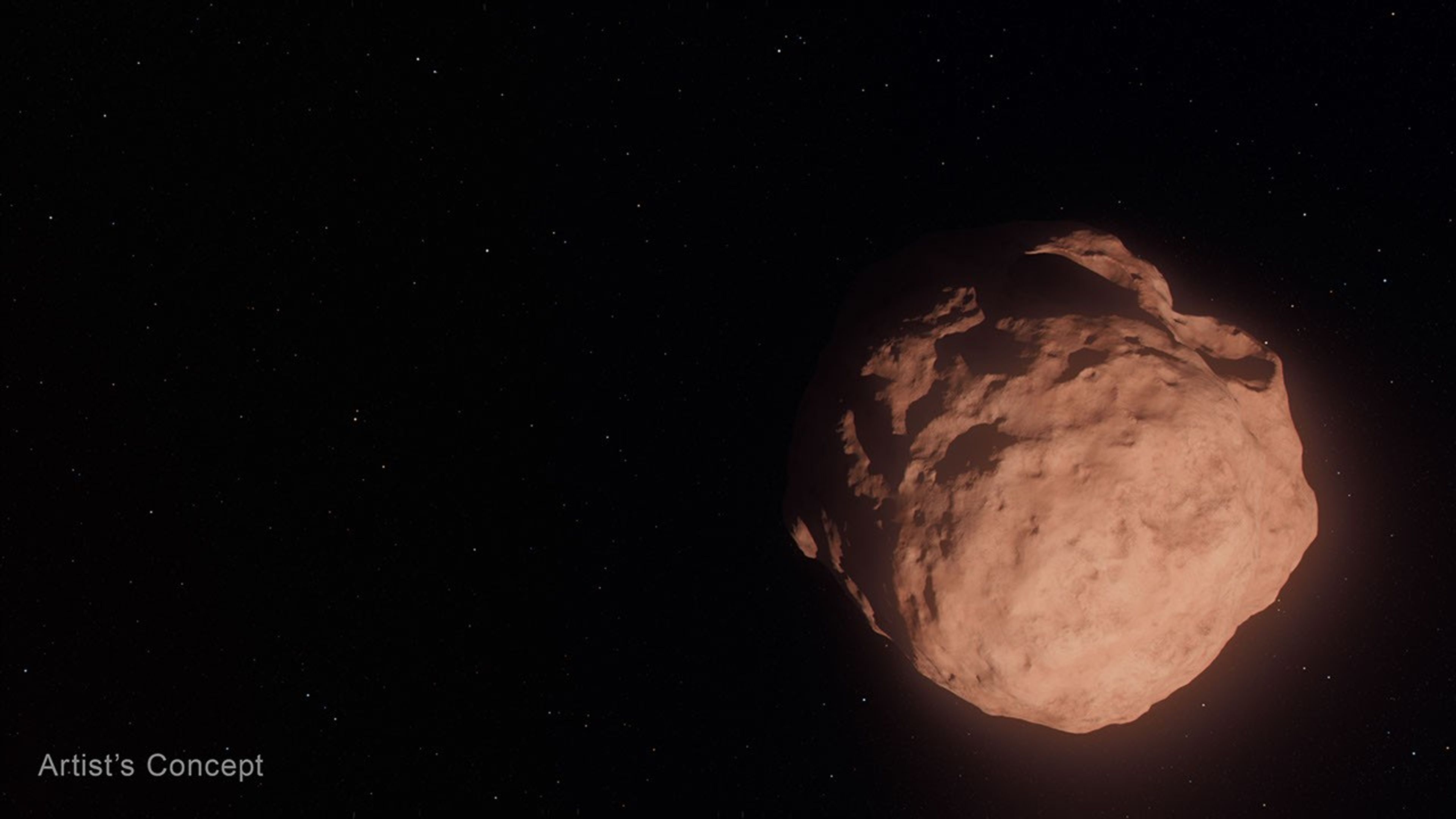
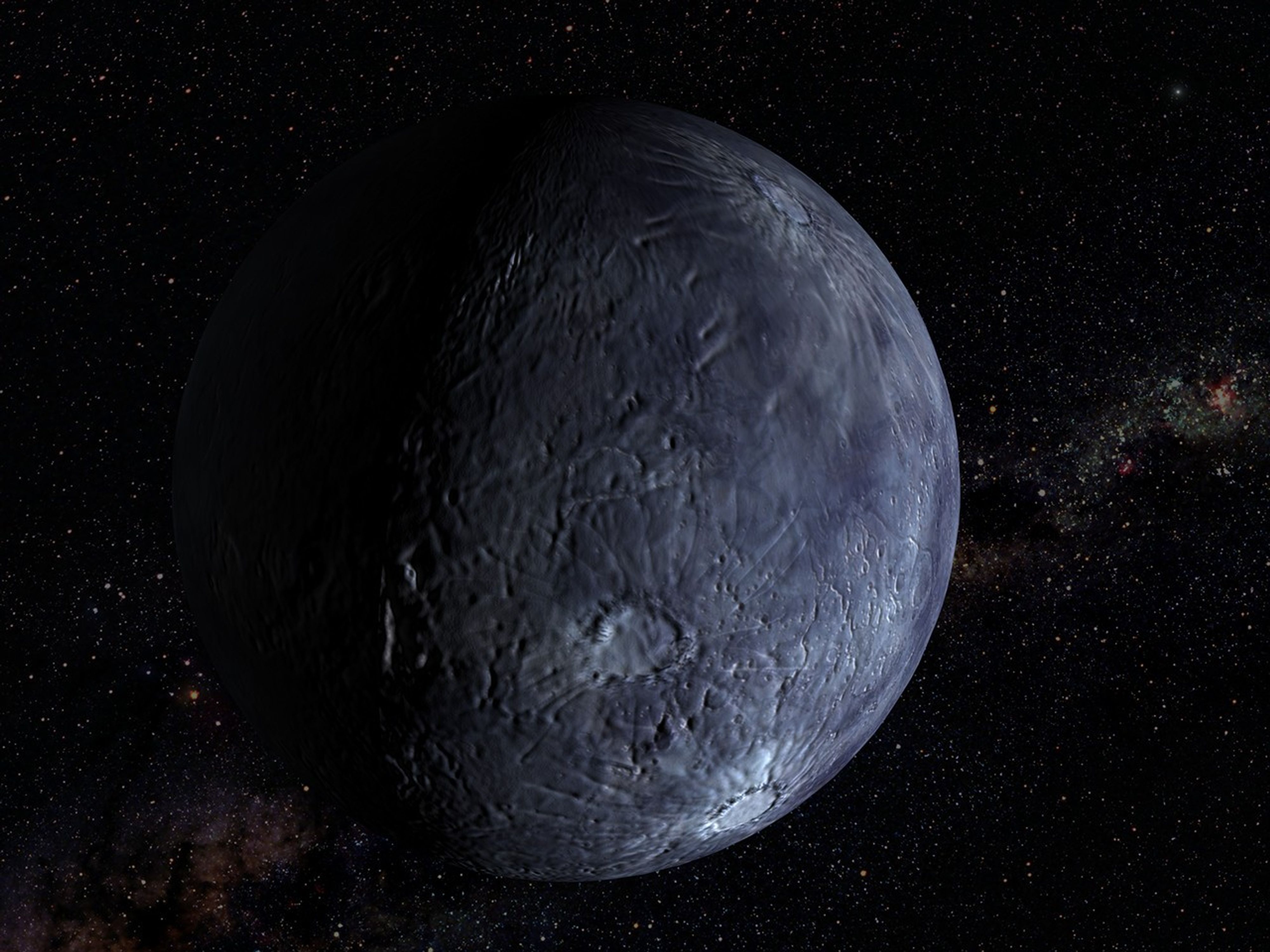
This artist’s concept depicts a Trans-Neptunian Object, a small, faint, icy body orbiting the Sun beyond the orbit of Neptune. These objects are so small that even with NASA’s Hubble and Webb space telescopes, they appear only as tiny points of light.
Artwork: NASA, ESA, Leah Hustak (STScI)
For the first time, scientists used the joint power of NASA’s Hubble and James Webb Space Telescopes to study some of the most far-flung bodies in our solar system, Trans-Neptunian Objects (TNOs). Some of these are the smallest and faintest ever directly seen. The researchers unexpectedly found fewer small TNOs than they expected, and that the colors of these bodies followed the same relationships as their larger family members.
These objects are typically small, faint, icy bodies orbiting the Sun beyond the orbit of Neptune. Most are more than 100 million times dimmer than objects visible to the unaided eye. In two complementary papers published Tuesday in The Astronomical Journal, teams analyzed the color, composition, and size distribution of 27 newly discovered tiny, dim TNOs.
This class of small bodies offers the best view into an early stage of planet-building, when a disk of dust and pebbles in orbit around the Sun coalesced into city-sized “planetesimals” — the solid building blocks that clump together to form planets — but had not yet merged into full-sized worlds. Beyond Neptune, this second stage never happened, leaving behind a frozen population of planetesimals.
In the deepest TNO survey to date, teams led by PhD candidates from the University of Victoria in Canada, under the guidance of the National Research Council of Canada, and Northern Arizona University in Flagstaff examined a patch of sky simultaneously with Hubble, observing the TNOs’ visible light, and Webb, observing their infrared light. The team of researchers measured the objects’ colors, which are like a fingerprint of the surface composition, as well as their sizes and determined their orbits.
In the coordinated observations, the teams studied two different types of TNOs. The first, dynamically “cold” TNOs, are on their original, relatively circular orbits around the Sun in the plane of the solar system. The second type, dynamically “hot” TNOs, formed between the current locations of Uranus and Neptune but were pushed outward where they are today when the outer gas giants migrated early in the solar system’s history. Today they reside in highly elliptical orbits and move in and out of the plane of our solar system.
NASA’s Goddard Space Flight Center; Lead Producer: Paul Morris
Prior to these observations, astronomers thought that small TNOs from both hot and cold populations would have undergone many collisions, changing their surfaces compared to larger TNOs. But that’s not what the observations showed. Instead, the small bodies look like their larger counterparts. This implies that collisions are not changing the surfaces significantly—perhaps because there are fewer collisions than expected, or because the TNOs somehow retain their primordial, pre-collision compositions. The teams are still trying to unravel this mystery.
“You could imagine a scenario where getting knocked around and fragmented would change the surface composition, and then you would see a different surface color for tiny TNOs compared to their larger siblings. So it’s really fascinating to see that the smallest objects are somehow ‘remembering’ and preserving the history of how they were made,” said Northern Arizona University PhD candidate Anastasia Morgan, who led the study of color and composition.
“These dynamically ‘hot’ TNOs retain a signature of where they were born, even though they’ve been orbitally scrambled since then,” said co-author David Trilling of Northern Arizona University.
Both the “hot” and “cold” populations seem to keep the same colors as when they were formed, with little change since the birth of the solar system.
The Webb data also allowed researchers to measure the number of objects of each size. They found that the overall size distributions for both populations were surprisingly similar.
“It’s very interesting that the process of planetesimal formation ends up producing the same distribution of sizes for both cold and hot populations, despite forming in different regions of the early solar system. The process seems to be insensitive to disk conditions, producing similar planetesimal sizes whether the disk is hot or cold, and dense or fluffy,” said University of Victoria PhD candidate Marielle Eduardo, who led the study on size distribution.
Researchers also found fewer of these very small bodies than they expected based on some planet formation models. Webb discovered 27 new, remarkably dim TNOs, one so faint it is equivalent to standing on Earth and seeing a small swarm of fireflies on the Moon. The smallest one they observed has a diameter of about 3 miles (5 kilometers), which is about five times smaller than what is possible to detect with the most sensitive ground-based telescopes.
This project would not have been possible without Hubble and Webb working together to detect and characterize these TNOs. With Hubble’s sensitivity in visible light and Webb’s in infrared, the space telescopes provide more insights than either can on its own.
The Hubble Space Telescope has been operating for over three decades and continues to make ground-breaking discoveries that shape our fundamental understanding of the universe. Hubble is a project of international cooperation between NASA and ESA (European Space Agency). NASA’s Goddard Space Flight Center in Greenbelt, Maryland, manages the telescope and mission operations. Lockheed Martin Space, based in Denver, also supports mission operations at Goddard. The Space Telescope Science Institute in Baltimore, which is operated by the Association of Universities for Research in Astronomy, conducts Hubble science operations for NASA.
The James Webb Space Telescope is the world’s premier space science observatory. Webb is solving mysteries in our solar system, looking beyond to distant worlds around other stars, and probing the mysterious structures and origins of our universe and our place in it. Webb is an international program led by NASA with its partners, ESA (European Space Agency) and CSA (Canadian Space Agency).
This artist’s concept depicts a Trans-Neptunian Object, a small, faint, icy body orbiting the Sun beyond the orbit of Neptune. These objects are so small that even with NASA’s Hubble and Webb space telescopes, they appear only as tiny points of light.
Tiny Worlds Discovered by Hubble and Webb
This video explains how Hubble and Webb are giving scientists a new look at some of the solar system’s oldest survivors and revealing new clues about how the building blocks of planets, including Earth, first formed.
Explore More
NASA’s Hubble Finds Kuiper Belt Duo May Be Trio
A team of researchers found a potential three-body system in the Kuiper Belt. The system, known as the Altjira, challenges traditional collision theories by suggesting that these triple systems might form directly from the gravitational collapse of material in the early solar disk.
NASA’s Webb Reveals the Ancient Surfaces of Trans-Neptunian Objects
Within the first two years of science operations, Webb took high-quality spectra of over 75 TNOs and provided the first comprehensive look at what they are made of.
Uncovering Icy Objects in the Kuiper Belt
Hubble observations of the outskirts of our solar system found a moon orbiting Makemake and several new moons around Pluto. These observations played a critical role in helping NASA plan the New Horizons spacecraft’s flyby of Pluto and beyond.
Hubble Harvests Distant Solar System Objects
Astronomers using clever techniques to cull the data archives of NASA’s Hubble Space Telescope have added 14 new TNOs to the catalog.
Kuiper Belt: Exploration
The Kuiper Belt is a doughnut-shaped region of icy objects beyond the orbit of Neptune. It is home to Pluto and most of the known dwarf planets and some comets.
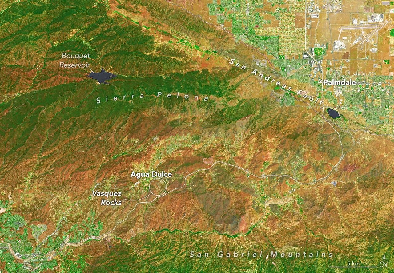
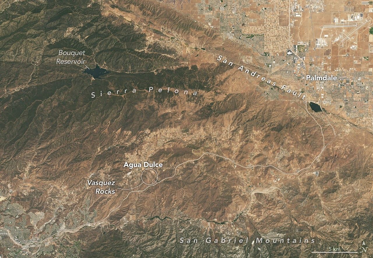
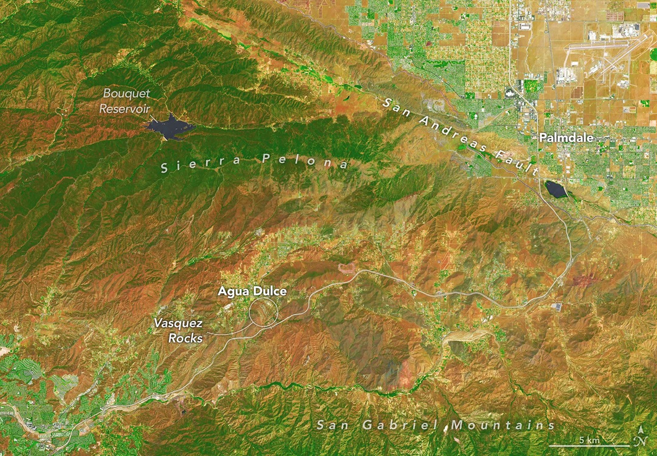
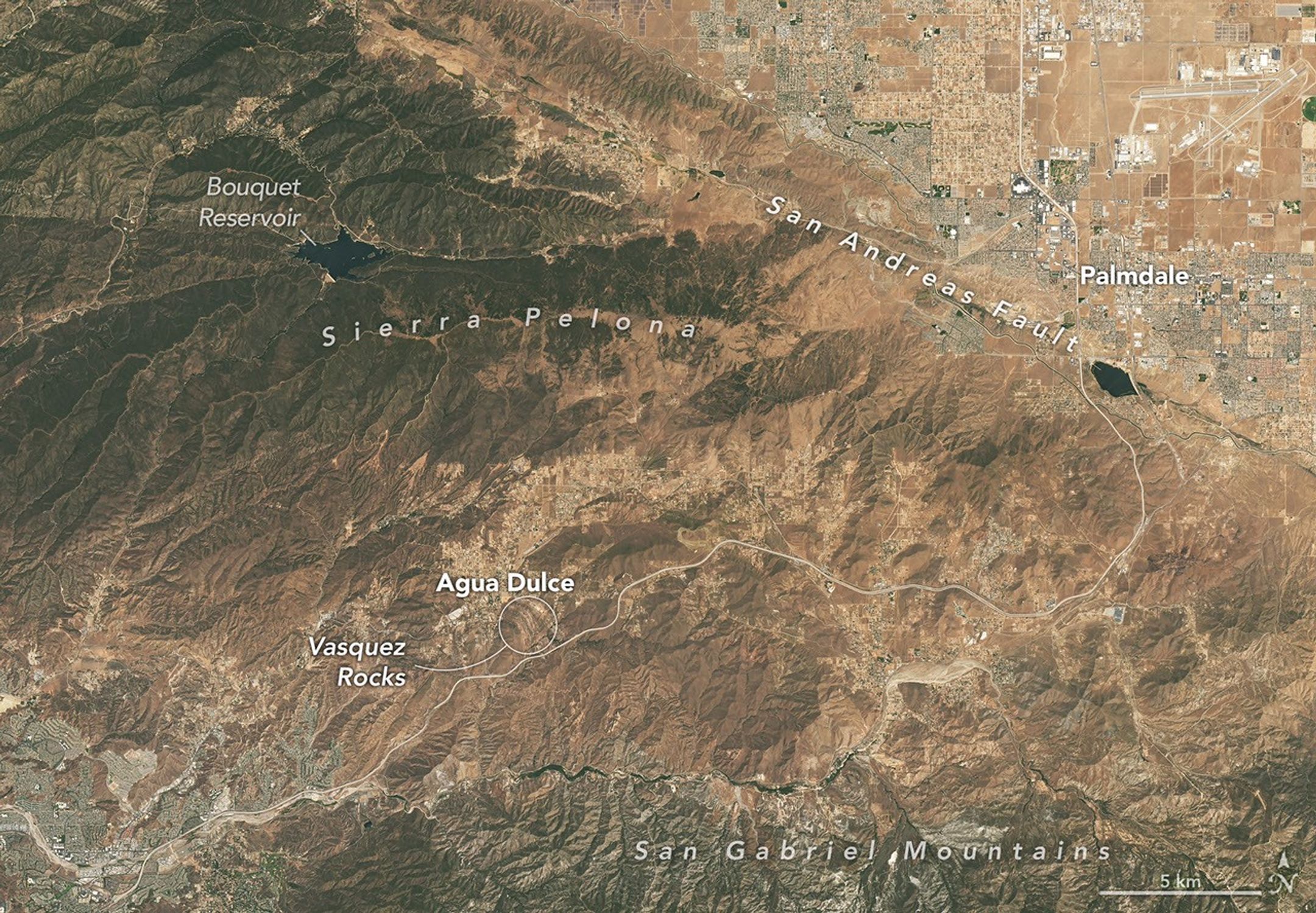
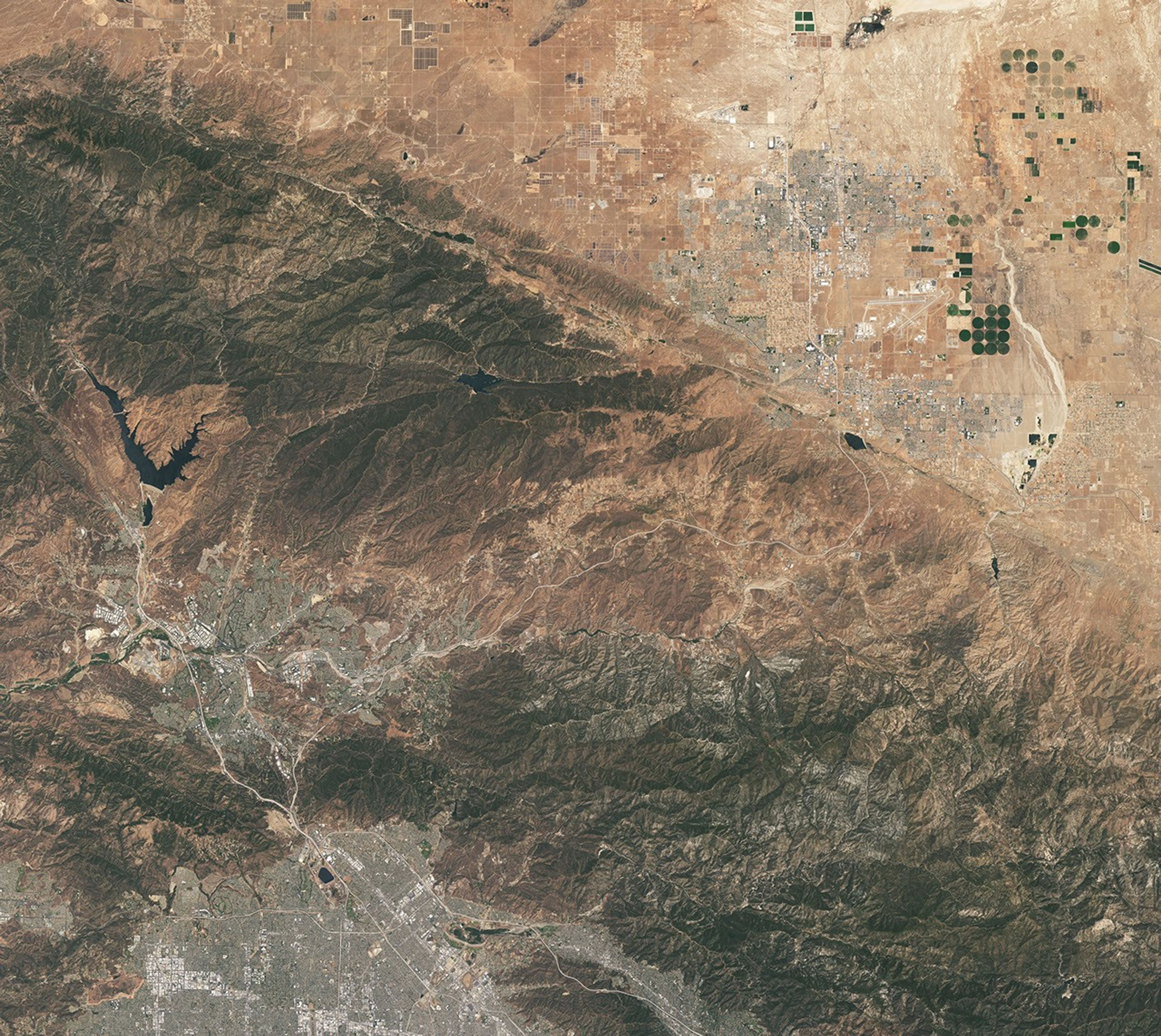
A patchwork of chaparral and sage scrub vegetation shades the hills and mountain ranges surrounding Agua Dulce and Vasquez Rocks in this pair of images captured by the OLI (Operational Land Imager) aboard Landsat 9 on July 28, 2026. The false-color image (bands 6-5-4) on the left incorporates shortwave-infrared and near-infrared observations that accentuate differences in vegetation and soil moisture in comparison to the natural-color image on the right. NASA Earth Observatory images by Michala Garrison.
Editor’s Note: Today’s story is the answer to the September Puzzler.
Several of the outcrops at Vasquez Rocks Natural Area in Southern California jut from the arid landscape of the Soledad Basin at remarkable angles. Geologists estimate that the tilt of sedimentary rock strata found in the area averages 50 degrees, steep enough that many of the otherworldly formations appear to point toward the stars.
That’s fitting, in some ways, because the rocks have served as one of the Star Trek franchise’s favorite backdrops ever since the show’s inaugural season, when Captain James T. Kirk scrambled up the jagged terrain during an iconic battle with a member of a reptilian alien species.
Viewed from space, the Vasquez Rocks are considerably less dramatic, but they show up clearly as bands of gray nestled between mountain ranges in these false-color (left) and natural-color (right) images captured by the OLI (Operational Land Imager) on Landsat 9. The false-color view (bands 6-5-4) incorporates shortwave-infrared and near-infrared observations that accentuate differences in the landscape’s vegetation in comparison to the natural-color image on the right.
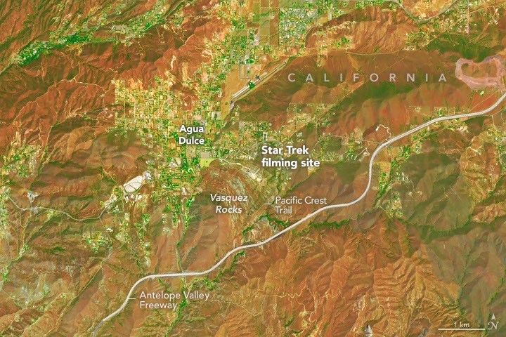
Proximity to Los Angeles and the freeway is among the reasons the tilted strata at Vasquez Rocks have long been a popular filming location for television producers. This false-color image (bands 6-5-4) was captured by the OLI (Operational Land Imager) aboard Landsat 9 on July 28, 2026.
NASA Earth Observatory/Michala Garrison
The Vasquez Rocks didn’t start out pointing skyward. When they were forming 25 million years ago, sediment was spread across alluvial fans—cone-shaped deposits that develop as fast-moving streams empty onto relatively flat plains. The sediment likely hadn’t traveled far, much of it eroding from nearby uplands. Over time, the alluvial fan deposits were buried and cemented into thick layers of sandstone and conglomerate rock.
Over millions of years, the region was then reshaped by the interaction of tectonic plates just to the east. Two plates grind past each other along a boundary that includes the San Andreas Fault, a strike-slip fault where the North American plate moves southeast and the Pacific plate northwest, contributing to the powerful tectonic forces that ripple throughout the region.
Eventually this tectonic activity led to the uplift and deformation of the Soledad Basin, with sedimentary layers gradually tilting, folding, and rotating. Once they were exposed at the surface, millions more years of weathering and erosion sculpted the formations further, removing softer material and leaving the more resistant sandstone and conglomerate fins and ridges that wow visitors today.
The rock formations represent far-flung moons and planets in several other Star Trek episodes and Vulcan, Spock’s home planet, in two Star Trek movies. Other productions have highlighted the Vasquez Rocks as well. They make appearances in dozens of other television shows and movies, including the science fiction series Westworld, For All Mankind, and Battlestar Galactica.
NASA Earth Observatory images by Michala Garrison, using Landsat data from the U.S. Geological Survey.Story by Adam Voiland.
Downloads
July 28, 2026: False color (bands 6-5-4)
JPEG (22.57 MB)
July 28, 2026: Natural color
JPEG (19.33 MB)
References & Resources
County of Los Angeles Department of Parks and Recreation, Vasquez Rocks Natural Area. Accessed September 4, 2026.
Directors Guild of America (2003, November) Vasquez Rocks. Accessed September 4, 2026.
Army Cpl. Freddie Stowers served as an infantryman during World War I and was posthumously awarded the Medal of Honor more than 70 years after his heroic actions in France in September 1918.
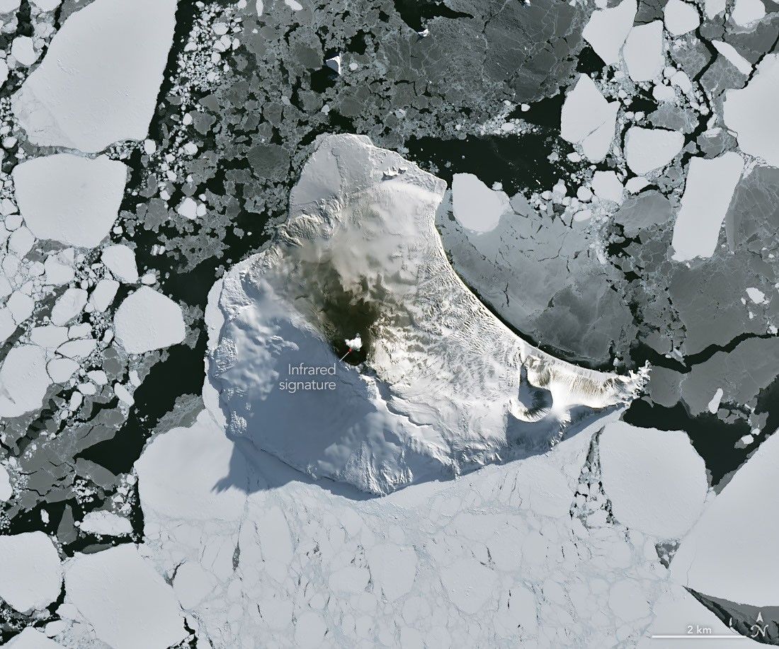
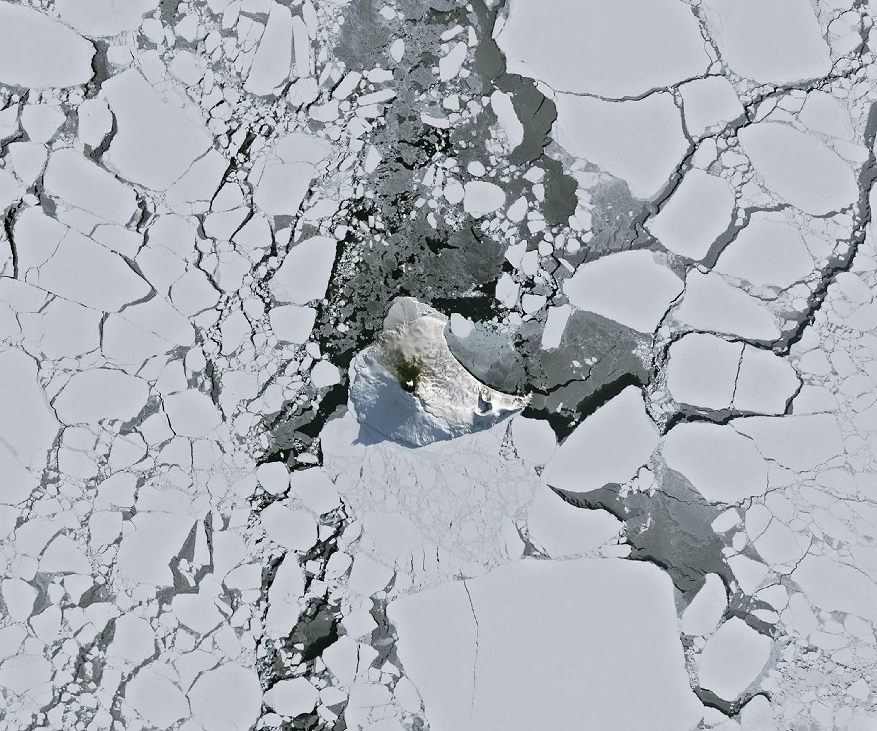
Mount Michael on Saunders Island, seen in this image acquired with the OLI (Operational Land Imager) on Landsat 8 on August 24, 2026, hosts a frequently active lava lake in its summit crater.
NASA Earth Observatory/Michala Garrison
Winter near the Antarctic Circle brings months of frozen darkness, when sea ice chokes ocean waters and many of its denizens hunker down to ride out the harsh conditions. But as winter began to release its icy grip, an uncommonly clear satellite image revealed that part of this remote realm was still very much awake, at least volcanically speaking.
Mount Michael, the stratovolcano at the center of Saunders Island, rises above the ice-filled South Atlantic Ocean in this image, acquired with the OLI (Operational Land Imager) on the NASA-USGS Landsat 8 satellite on August 24, 2026. The natural-color image is overlaid with an infrared signal (OLI bands 7-6-5), shown in red, revealing heat from the persistent lava lake in its summit crater. A puff of a volcanic plume hovering over the peak, along with darkened snow on its northern slopes, also suggests ongoing activity.
Saunders Island is one of the South Sandwich Islands, a string of small volcanic peaks about 350 kilometers (220 miles) long that formed from the South American plate subducting beneath the tiny South Sandwich plate. Regular eruptions, including at Mount Michael, have occurred on these islands in recent centuries.
Because of the volcanoes’ remoteness, scientists rely on satellite data to understand their activity. An analysis of thermal anomalies in Landsat, Sentinel, and ASTER (Advanced Spaceborne Thermal Emission and Reflection Radiometer) observations spanning 30 years led researchers to conclude that Mount Michael hosts a persistent lava lake in its summit crater. Only a handful of other volcanoes on Earth, including Kīlauea, Nyamulagira, and Erta Ale, are known to have similar, frequently active features.
Thermal observations from the MODIS (Moderate Resolution Imaging Spectroradiometer) and VIIRS (Visible Infrared Imaging Radiometer Suite) instruments have also enabled long-term monitoring of Mount Michael. Data provided through MIROVA, a near-real-time volcanic hot spot detection system, indicate that low-intensity activity has been ongoing at the volcano for the past several years. Other observations from NASA’s Aura satellite show that emissions of sulfur dioxide and other gases are common at Mount Michael.
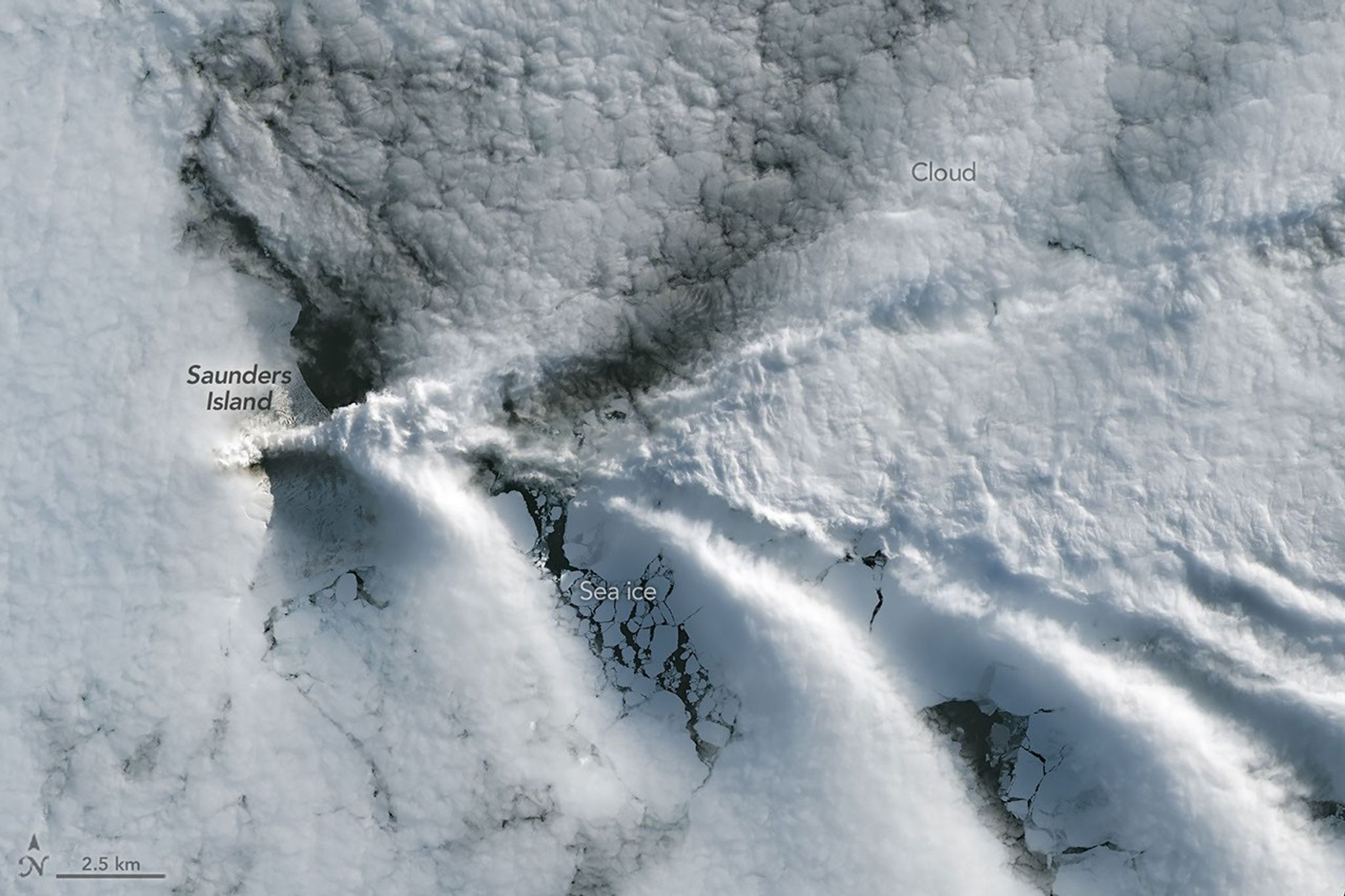
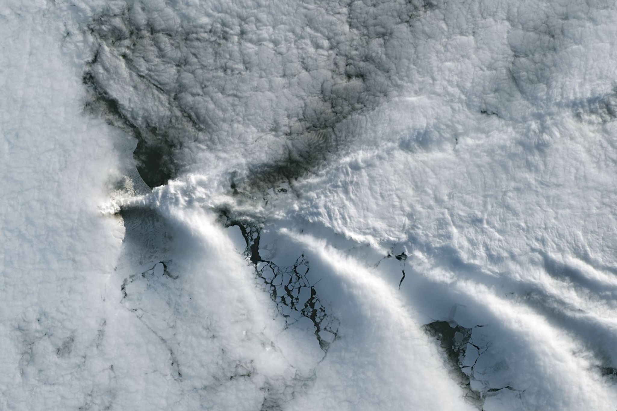
Wave clouds form downwind of Saunders Island in this image acquired with the OLI (Operational Land Imager) on Landsat 9 on September 1, 2026.
NASA Earth Observatory/Michala Garrison
The cloud-free window over Mount Michael would close in short order. One week later, when Landsat 9 passed over the island, a more active atmosphere had returned. But the weather patterns interacted with the island to put on a spectacle of their own. The 843-meter-high (2,766-foot-high) peak jutting from the ocean disturbed passing winds to produce a series of wave clouds resembling the wake of a ship, a familiar phenomenon in this region. False-color imagery captured by NASA’s Aqua satellite indicates that a volcanic track caused by degassing sulfur dioxide was likely present as well.
NASA Earth Observatory images by Michala Garrison, using Landsat data from the U.S. Geological Survey. Story by Lindsey Doermann.
Downloads
August 24, 2026
JPEG (4.27 MB)
September 1, 2026
JPEG (1.14 MB)
References & Resources
Global Volcanism Program (2026) Saunders. Accessed September 4, 2026.
Discover the cosmos! Each day a different image or photograph of our fascinating universe is featured, along with a brief explanation written by a professional astronomer.
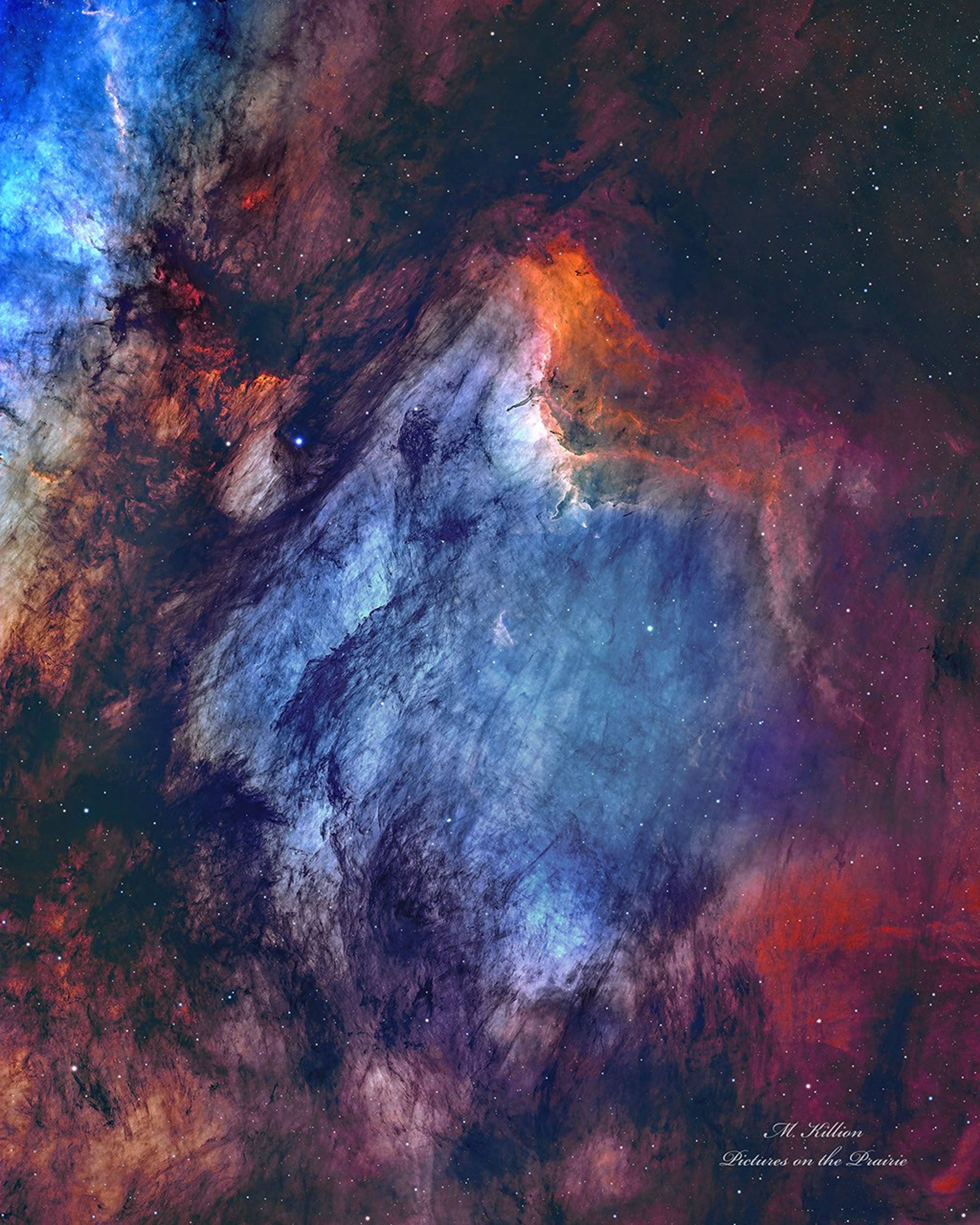
The Pelican Nebula in Gas, Dust, and Stars
Explanation: The Pelican Nebula is slowly being transformed. IC 5070 (an official designation) is divided from the larger North America Nebula by a molecular cloud filled with dark dust. The deep featured picture from Utah, USA incorporates 25 hours of exposure and brings out great details of this filamentary dust. The Pelican Nebula receives much study because it is a particularly active mix of star formation and evolving gas clouds. The light from young energetic stars is slowly transforming the cold gas to hot gas, with the advancing boundary between the two, known as an ionization front, visible in bright orange on the upper right. Particularly dense tentacles of cold gas remain. Millions of years from now, the Pelican Nebula, bounded by dark nebula LDN 935, might no longer be known as the Pelican, as the balance and placement of stars and gas will surely leave something that appears completely different.
Les casinos en ligne reproduisent sur Internet des jeux traditionnellement proposés dans les établissements physiques. Ils peuvent offrir des machines à sous, des jeux de cartes, de la roulette ou des parties animées en direct. Leur accessibilité ne signifie cependant pas qu’ils sont légalement autorisés dans tous les pays.
Quels jeux sont autorisés en France ?
La réglementation française distingue les casinos physiques autorisés des jeux accessibles sur Internet. En ligne, les opérateurs agréés peuvent proposer des paris sportifs, des paris hippiques et du poker.
En revanche, les machines à sous et les jeux de table de casino ne sont pas autorisés en ligne. Un site accessible depuis la France peut donc rester illégal, même lorsqu’il affiche une licence internationale.
Les risques associés aux sites non autorisés
L’utilisation d’un casino en ligne non autorisé peut exposer le joueur à plusieurs problèmes. Il peut s’agir d’un refus de paiement, d’une fermeture soudaine du compte, d’un vol de données ou d’une absence de recours efficace en cas de litige.
Les autorités françaises peuvent également demander le blocage de plateformes proposant illégalement des jeux d’argent sur le territoire.
Reconnaître les principaux signaux d’alerte
Un site doit être considéré avec prudence lorsqu’il :
promet des gains garantis ;
exerce une forte pression pour effectuer un dépôt ;
dissimule ses conditions de retrait ;
réclame des frais imprévus pour libérer des gains ;
ne fournit aucune information vérifiable sur son exploitant ;
utilise abusivement le logo d’une autorité française.
La présence d’une licence étrangère ne remplace pas l’agrément exigé en France.
Protéger son budget
Aucune méthode ne garantit un bénéfice régulier aux jeux de hasard. Le résultat dépend principalement du hasard et l’opérateur conserve généralement un avantage mathématique.
Pour réduire les risques, il faut déterminer une limite de dépenses, ne jamais emprunter pour jouer et faire des pauses régulières. Les mineurs ne doivent jamais accéder aux jeux d’argent.
Lorsqu’une personne ressent une perte de contrôle, elle peut utiliser les dispositifs d’auto-exclusion ou demander une interdiction volontaire de jeux. Demander de l’aide rapidement permet de mieux protéger sa santé et sa situation financière.
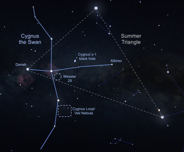
This image shows an illustration of the constellation Cygnus, Latin for “swan,” in the night sky. The Cygnus Loop supernova remnant, also known as the Veil Nebula, is located near one of the swan’s wings, outlined here in a rectangular box.
NASA
Bird constellations abound in the night sky, including Cygnus, the majestic swan. Easy to find with its dazzling stars, it is one of the few constellations that look like its namesake, and it is full of treasures. Visible in the Northern Hemisphere all summer long, there’s so much to see and even some things that can’t be seen. To locate Cygnus, start with the brightest star, Deneb, also the northeasternmost and dimmest star of the Summer Triangle. The Summer Triangle is made up of three bright stars from three different constellations – read more about it in the September 2022 issue of Night Sky Notes. “Deneb” is an Arabic word meaning the tail. Then travel into the triangle until you see the star Albireo, sometimes called the “beak star” in the center of the summer triangle. Stretching out perpendicular from this line are two stars that mark the crossbar, or the wings, and there are also faint stars that extend the swan’s wings.
From light-polluted skies, you may only see the brightest stars, sometimes called the Northern Cross. In a darker sky, the line of stars marking the neck of the swan travels along the band of the Milky Way. A pair of binoculars will resolve many stars along that path, including a sparkling open cluster of stars designated Messier 29, found just south of the swan’s torso star. This grouping of young stars may appear reddish due to nearby excited gas.
Let’s go deeper. While the bright beak star Albireo is easy to pick out, a telescope will let its true beauty shine! Like a jewel box in the sky, magnification shows a beautiful visual double star, with a vivid gold star and a brilliant blue star in the same field of view. There’s another marvel to be seen with a telescope or strong binoculars – the Cygnus Loop. Sometimes known as the Veil Nebula, you can find this supernova remnant (the gassy leftovers blown off of a large dying star) directly above the final two stars of the swan’s eastern wing. It will look like a faint ring of illuminated gas about three degrees across (six times the diameter of the Moon).
The black hole named Cygnus X-1 formed when a large star caved in. This black hole pulls matter from the blue star beside it.
Image: NASA, CXC, Melissa Weiss (CXC)
Speaking of long-dead stars, astronomers have detected a high-energy X-ray source in Cygnus that we can’t see with our eyes or backyard telescopes, but that is detectable by NASA’s Chandra X-ray Observatory. Discovered in 1971 during a rocket flight, Cygnus X-1 is the first X-ray source to be widely accepted as a black hole. This black hole is the final stage of a giant star’s life, with a mass of about 20 Suns. Cygnus X-1 is spinning at a phenomenal rate – more than 800 times a second – while devouring a nearby star. Astronomically speaking, this black hole is in our neighborhood, 6,070 light years away. But it poses no threat to us, just offers a new way to study the universe.
Check out the beautiful bird in your sky this evening, and you will be delighted to add Cygnus to your go-to summer viewing list and visit NASA’s Black Hole Basics page to learn more!
Originally posted by Dave Prosper: May 2023 Last Updated by Kat Troche: July 2026
Crew chiefs assigned to the Air National Guard’s 171st Air Refueling Wing, based near Pittsburgh, keep two aerial refueling flying squadrons of KC-135 Stratotanker refueling tanker aircraft mission ready.