1,000 Museum Visitors Dive Into NASA Sea Level Science on World Ocean Day

3 min read

1,000 Museum Visitors Dive Into NASA Sea Level Science on World Ocean Day

Several people place their hands and forearms on a brightly lit, abstract patterned surface under colorful fluorescent lighting.
Participants reach into an augmented reality sandbox, reshaping the terrain as projected contour lines and colors illustrate topographic features and elevation changes.
University of Georgia Marine Extension and Georgia Sea Grant

More than 1,000 visitors explored NASA sea level science firsthand during World Ocean Day at the University of Georgia Aquarium on Skidaway Island on June 6, 2026. The free event was supported by NASA’s Science Activation program through the Sea Level Education, Awareness, and Literacy (SEAL) project – a national effort that connects NASA sea level rise data with educators and coastal communities, particularly those historically underserved and already experiencing sea level impacts.

SEAL is a partnership between NASA and four NOAA Sea Grant programs working together to expand sea level rise understanding across U.S. coastal regions. By co-developing lesson plans, interactive activities, and place‑based learning experiences, SEAL helps educators engage learners with real NASA observations, models, and projections while strengthening community resilience to climate change.

During World Ocean Day, SEAL partners at Marine Extension and Georgia Sea Grant and the Coastal Equity and Resiliency Hub at Georgia Tech led hands‑on activities that brought sea level science to life. Visitors played the “Tumbling Tower” game, where removing blocks represents different community impacts from rising seas, and made “sea level friendship bracelets” that used colored glass beads to represent observed sea level rise along local coastlines.

The event also marked the debut of a new augmented reality sand box developed through SEAL. Guests shaped sand into coastal landscapes and watched NASA-informed sea level rise projections transform their creations in real time. Participants could experiment with resilience strategies, such as adding dunes or relocating homes, to see how adaptations might help communities prepare for future change.

Educators – formal, informal, home-based, and more – attending the event were able to take home four different SEAL lesson plans designed for both classrooms and informal learning settings. These materials help students explore sea level rise processes, modeling, variation, and impacts through NASA data and interactive STEM activities. SEAL aims to make all lesson plans developed through the project available online, but until then, please email Shannon Matzke to request digital copies.

“World Ocean Day is an annual tradition at the UGA Aquarium,” said Shannon Matzke, Marine Educator and Public Program Coordinator at UGA Marine Extension and Georgia Sea Grant. “With the support of NASA’s Science Activation program, this year’s event was free, which allowed us to reach more people and different audiences than we typically see. Incorporating SEAL activities made the day even more impactful for visitors – many of whom live in coastal communities already experiencing the effects of sea level rise.”

The SEAL project is supported by NASA cooperative agreement award number NNH21ZDA001N-SCIACT and is part of the NASA Science Activation Program portfolio, which connects learners with authentic NASA science experiences through partnerships with educators and community organizations.

Source: science.nasa.gov

APOD: 2026 September 8 – Hubble: Decagon Around Saturn’s South Pole

APOD

Astronomy Picture of the Day

Discover the cosmos! Each day a different image or photograph of our fascinating universe is featured, along with a brief explanation written by a professional astronomer.

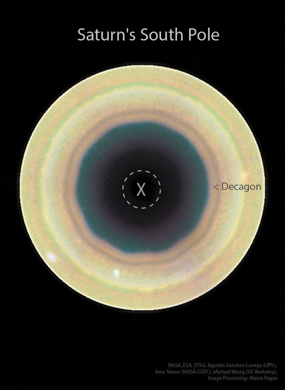
A dark field has a bright circular disk near the center. Around the center of this disk are bands. One of the bands  appear particularly geometric and appears to have 10 sides. Please see the explanation for more detailed information.

Hubble: Decagon Around Saturn’s South Pole

Explanation: Why are Saturn’s poles geometric? Saturn’s North Pole has been known to be surrounded by a hexagonal (6 sides) cloud since discovery in 1987 in data taken by NASA’s Voyager spacecrafts, which quickly flew past the ringed world in the early 1980s. Now, recent observations of Saturn by the Hubble Space Telescope reveal a slightly different geometric cloud pattern around the South Pole: a decagon (10 sides). The geometric boundaries are possibly caused by waves when the fast-moving gas away from the poles interacts with slower-moving gas closer to the poles. In the featured image composite by the Hubble taken last year, the South Pole of Saturn is marked by an X and surrounded by bands of circulating clouds. The decagon appears most prominent in the dark inner regions. The northern hexagon has proven stable for over 40 years, while the stability of the southern decagon will surely remain a topic of research.

APOD’s main NASA site is moving: From apod.nasa.gov to science.nasa.gov/apod
Tomorrow’s picture: open space

Date September 8, 2026
Credit NASA, ESA, STScI, HST; A. Sánchez-Lavega (UPV), A. Simon (NASA-GSFC), M. Wong (UC Berkeley); Processing: A. Pagan (STScI)
Authors & editors: Robert Nemiroff, Jerry Bonnell, Cecilia Chirenti, Keighley Rockcliffe
A service of: ASD at NASA / GSFC,
NASA Science Activation & Michigan Tech. U.

Source: science.nasa.gov

The Otherworldly Geology of Vasquez Rocks


false color
natural color

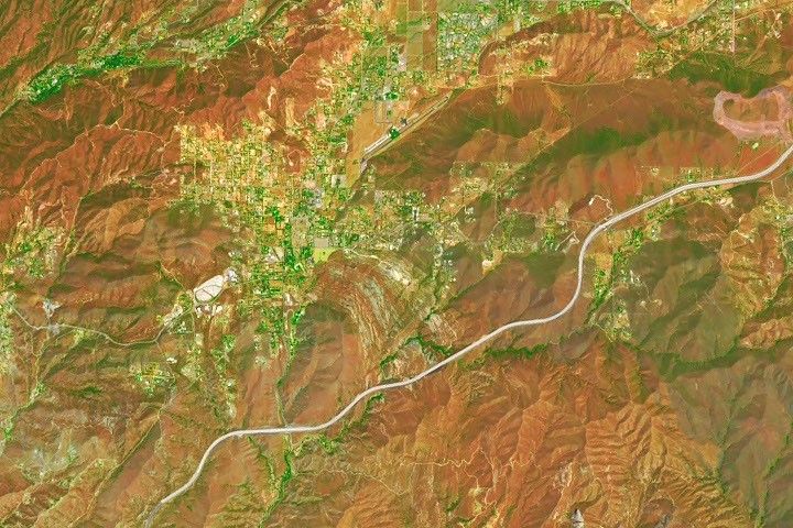
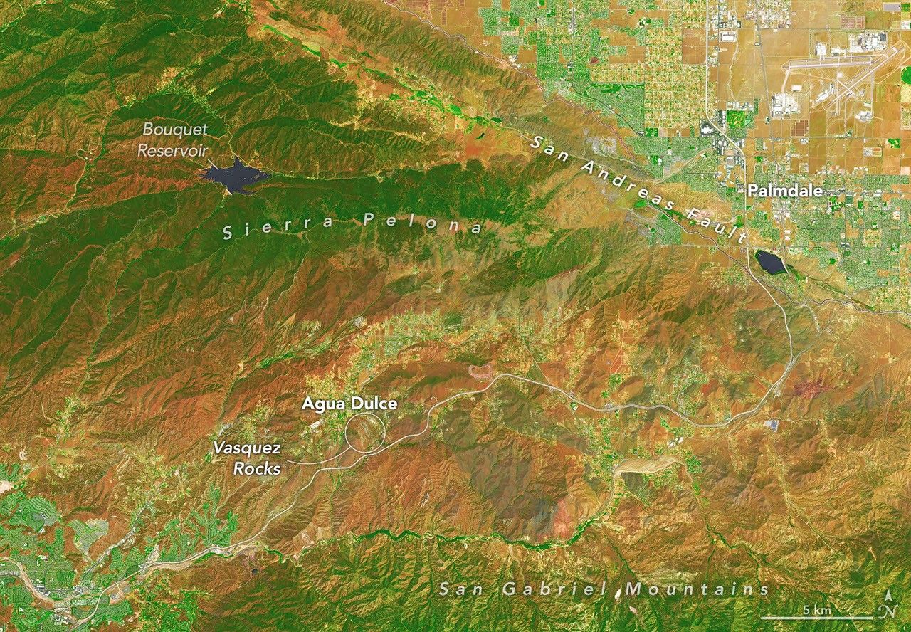
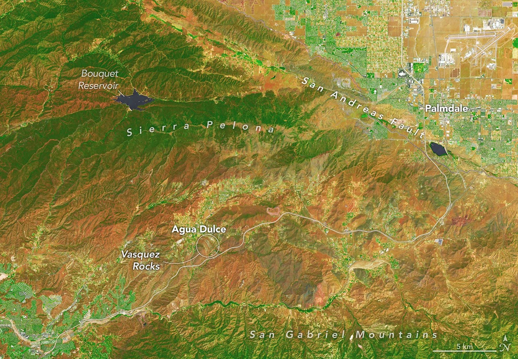
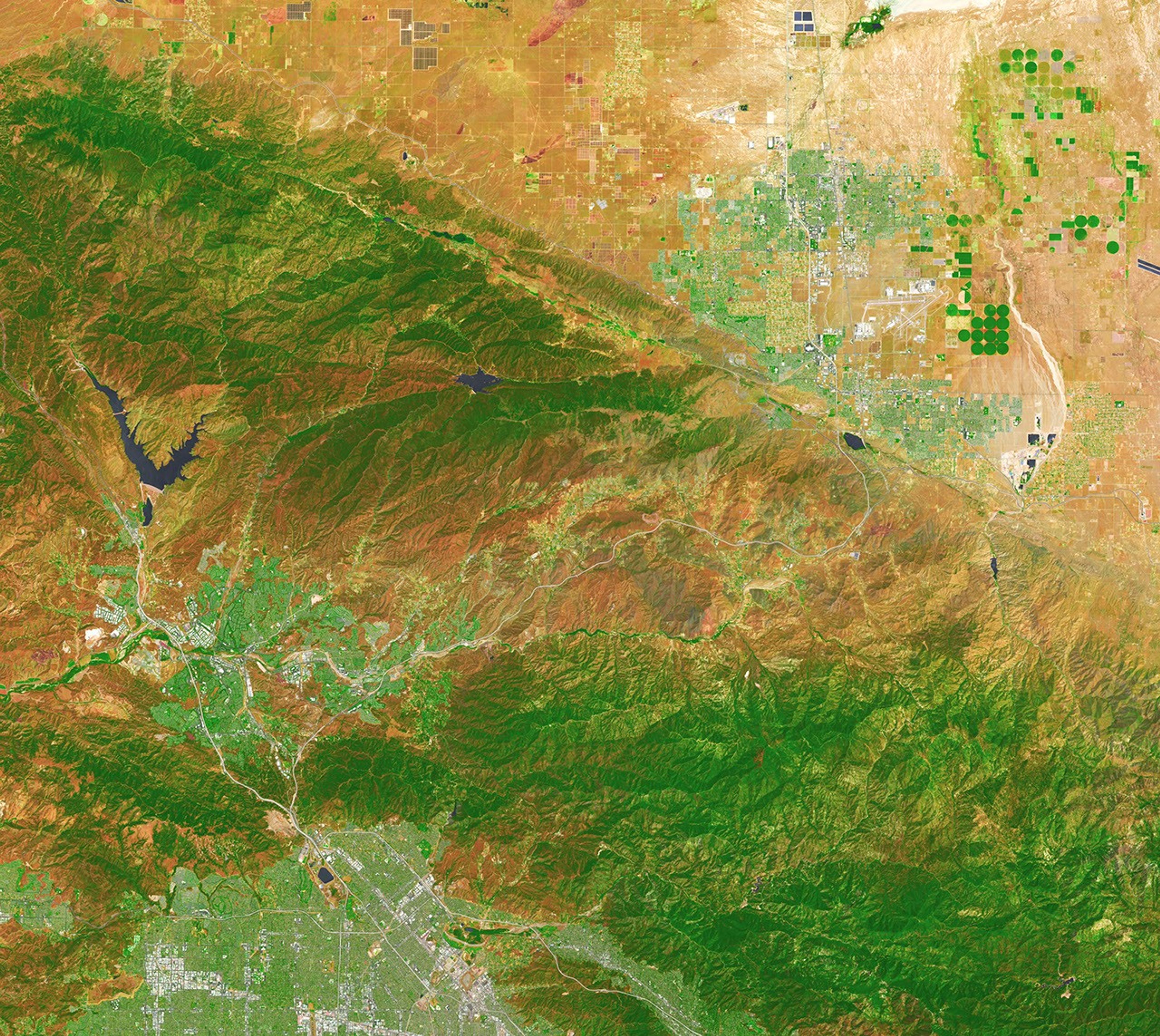
In this false-color image, areas with more extensive vegetation on the Sierra Pelona retain more moisture than the hills surrounding Agua Dulce, making the Sierra Pelona appear dark green in comparison to the rusty brown coloration of the lower hills. Vasquez Rocks appears as a patch of curved gray stripes near the center of the image.
NASA Earth Observatory/Michala Garrison

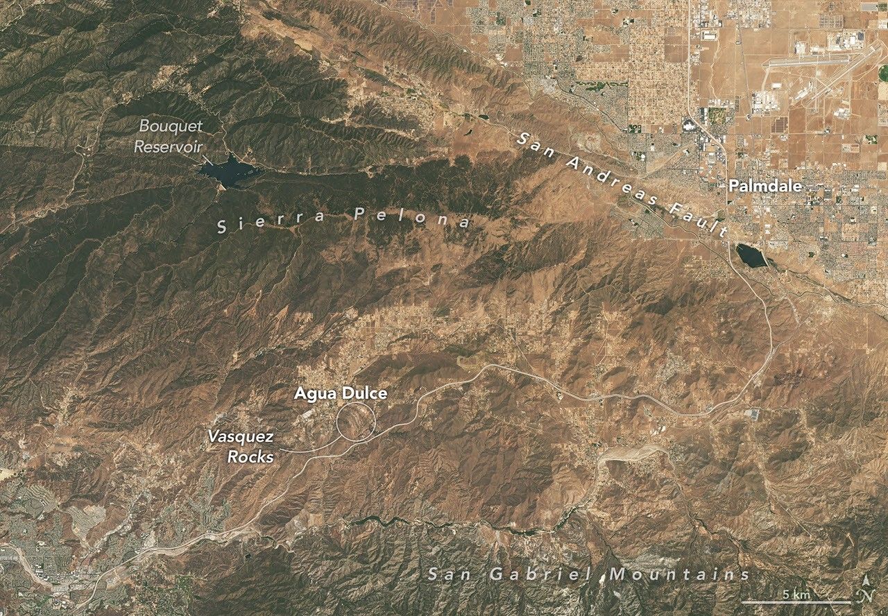
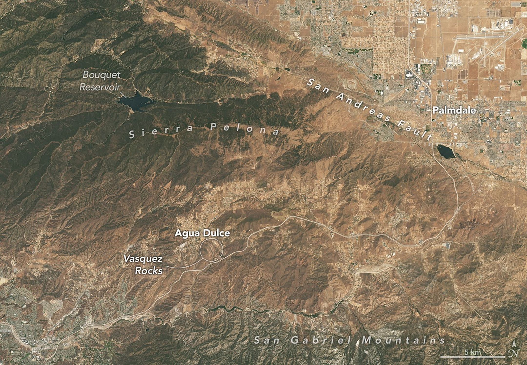
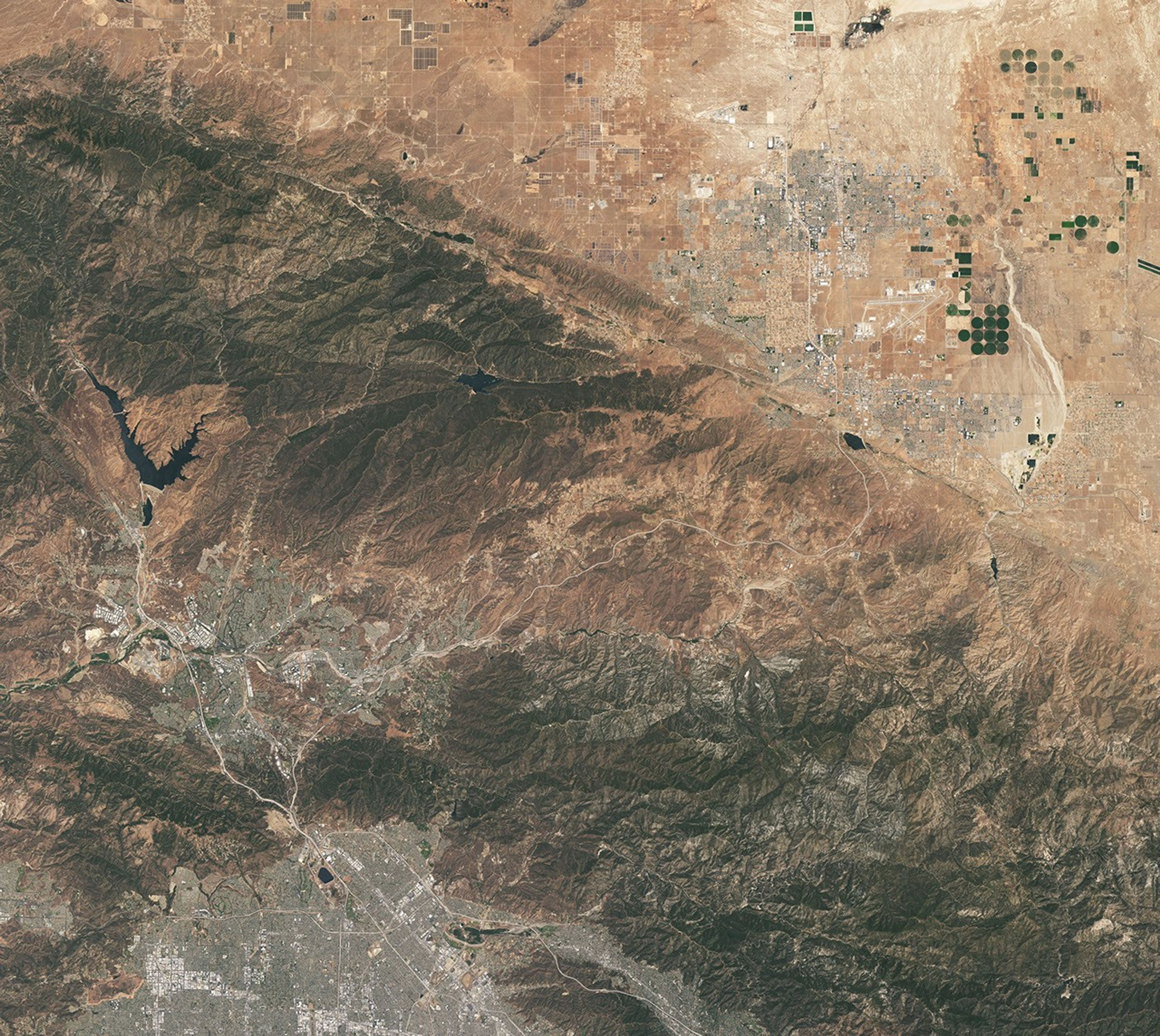
This natural-color image shows the same area, but there is less difference in colors between higher-elevation and lower-elevation vegetation. Most features in the image are shades of brown.
NASA Earth Observatory/Michala Garrison

In this false-color image, areas with more extensive vegetation on the Sierra Pelona retain more moisture than the hills surrounding Agua Dulce, making the Sierra Pelona appear dark green in comparison to the rusty brown coloration of the lower hills. Vasquez Rocks appears as a patch of curved gray stripes near the center of the image.
NASA Earth Observatory/Michala Garrison

This natural-color image shows the same area, but there is less difference in colors between higher-elevation and lower-elevation vegetation. Most features in the image are shades of brown.
NASA Earth Observatory/Michala Garrison


false color

natural color


A patchwork of chaparral and sage scrub vegetation shades the hills and mountain ranges surrounding Agua Dulce and Vasquez Rocks in this pair of images captured by the OLI (Operational Land Imager) aboard Landsat 9 on July 28, 2026. The false-color image (bands 6-5-4) on the left incorporates shortwave-infrared and near-infrared observations that accentuate differences in vegetation and soil moisture in comparison to the natural-color image on the right. NASA Earth Observatory images by Michala Garrison.

Editor’s Note: Today’s story is the answer to the September Puzzler.

Several of the outcrops at Vasquez Rocks Natural Area in Southern California jut from the arid landscape of the Soledad Basin at remarkable angles. Geologists estimate that the tilt of sedimentary rock strata found in the area averages 50 degrees, steep enough that many of the otherworldly formations appear to point toward the stars.  

That’s fitting, in some ways, because the rocks have served as one of the Star Trek franchise’s favorite backdrops ever since the show’s inaugural season, when Captain James T. Kirk scrambled up the jagged terrain during an iconic battle with a member of a reptilian alien species.

Viewed from space, the Vasquez Rocks are considerably less dramatic, but they show up clearly as bands of gray nestled between mountain ranges in these false-color (left) and natural-color (right) images captured by the OLI (Operational Land Imager) on Landsat 9. The false-color view (bands 6-5-4) incorporates shortwave-infrared and near-infrared observations that accentuate differences in the landscape’s vegetation in comparison to the natural-color image on the right.

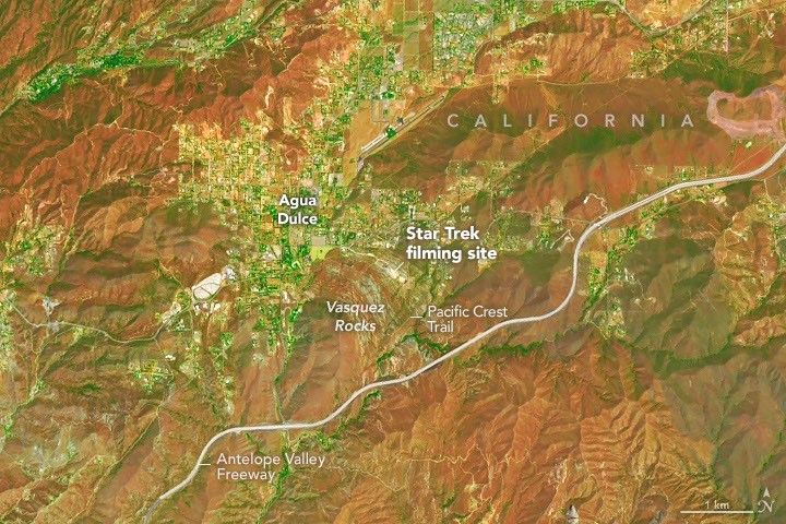
A zoomed-in view of the Vasquez Rocks part of the image highlights a sandy parking lot where Star Trek scenes were filmed, the Antelope Valley Freeway, and the nearby community of Agua Dulce.
Proximity to Los Angeles and the freeway is among the reasons the tilted strata at Vasquez Rocks have long been a popular filming location for television producers. This false-color image (bands 6-5-4) was captured by the OLI (Operational Land Imager) aboard Landsat 9 on July 28, 2026.
NASA Earth Observatory/Michala Garrison

The Vasquez Rocks didn’t start out pointing skyward. When they were forming 25 million years ago, sediment was spread across alluvial fans—cone-shaped deposits that develop as fast-moving streams empty onto relatively flat plains. The sediment likely hadn’t traveled far, much of it eroding from nearby uplands. Over time, the alluvial fan deposits were buried and cemented into thick layers of sandstone and conglomerate rock.

Over millions of years, the region was then reshaped by the interaction of tectonic plates just to the east. Two plates grind past each other along a boundary that includes the San Andreas Fault, a strike-slip fault where the North American plate moves southeast and the Pacific plate northwest, contributing to the powerful tectonic forces that ripple throughout the region.

Eventually this tectonic activity led to the uplift and deformation of the Soledad Basin, with sedimentary layers gradually tilting, folding, and rotating. Once they were exposed at the surface, millions more years of weathering and erosion sculpted the formations further, removing softer material and leaving the more resistant sandstone and conglomerate fins and ridges that wow visitors today.

The rock formations represent far-flung moons and planets in several other Star Trek episodes and Vulcan, Spock’s home planet, in two Star Trek movies. Other productions have highlighted the Vasquez Rocks as well. They make appearances in dozens of other television shows and movies, including the science fiction series Westworld, For All Mankind, and Battlestar Galactica.

NASA Earth Observatory images by Michala Garrison, using Landsat data from the U.S. Geological Survey. Story by Adam Voiland.

References & Resources

You may also be interested in:

Stay up-to-date with the latest content from NASA as we explore the universe and discover more about our home planet.

Digging Back in Time in the UAE

5 min read

Once below a shallow sea, Jabal al Fāyah now stands above the desert in the United Arab Emirates as a…

Article

What Lake Bonneville Left Behind

5 min read

The drying of the massive lake exposed playas that became the setting for feats of engineering and technological ingenuity, as…

Article

Pumice Rafts Encroach on Admiralty Islands

4 min read

Buoyant volcanic rock fragments from an underwater eruption drifted across the Bismarck Sea and choked island coasts.

Article

Source: science.nasa.gov
APOD: 2026 September 7 – The Pelican Nebula in Gas, Dust, and Stars

APOD

Astronomy Picture of the Day

Discover the cosmos! Each day a different image or photograph of our fascinating universe is featured, along with a brief explanation written by a professional astronomer.

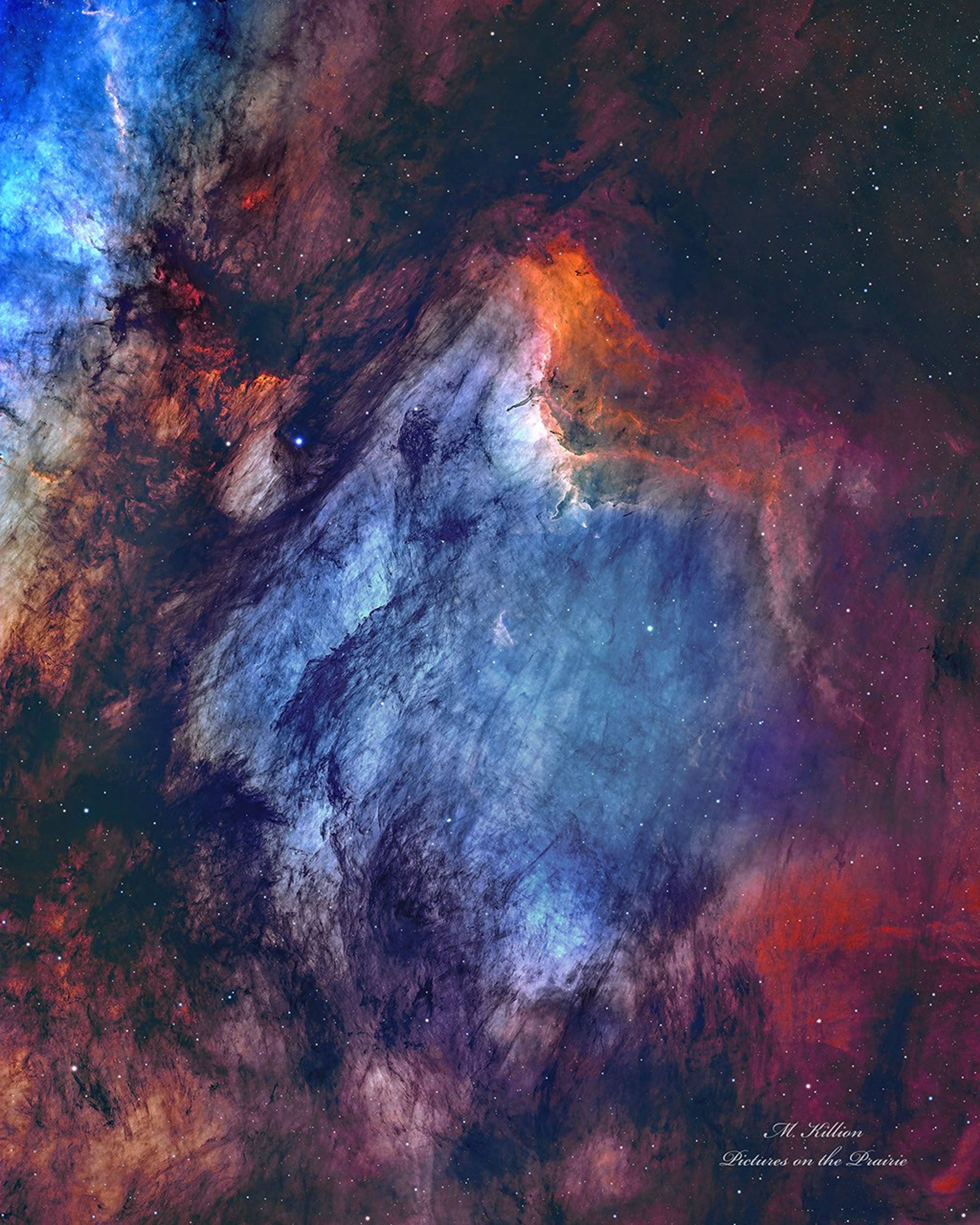
A busy starfield is dominated by red and blue glowing gas and dark filamentary dust. The nebula appears to some to have the shape of a pelican.

The Pelican Nebula in Gas, Dust, and Stars

Explanation: The Pelican Nebula is slowly being transformed. IC 5070 (an official designation) is divided from the larger North America Nebula by a molecular cloud filled with dark dust. The deep featured picture from Utah, USA incorporates 25 hours of exposure and brings out great details of this filamentary dust. The Pelican Nebula receives much study because it is a particularly active mix of star formation and evolving gas clouds. The light from young energetic stars is slowly transforming the cold gas to hot gas, with the advancing boundary between the two, known as an ionization front, visible in bright orange on the upper right. Particularly dense tentacles of cold gas remain. Millions of years from now, the Pelican Nebula, bounded by dark nebula LDN 935, might no longer be known as the Pelican, as the balance and placement of stars and gas will surely leave something that appears completely different.

APOD’s main site is moving: From apod.nasa.gov to science.nasa.gov/apod
Tomorrow’s picture: geometric Saturn

Date: September 7, 2026
Credit & Copyright: Mark Killion
Authors & editors: Robert Nemiroff, Jerry Bonnell, Cecilia Chirenti, Keighley Rockcliffe
A service of: ASD at NASA / GSFC,
NASA Science Activation & Michigan Tech. U.

Source: science.nasa.gov
A Bright Spot at Mount Michael

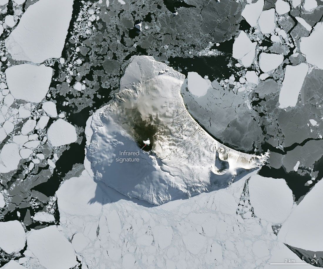
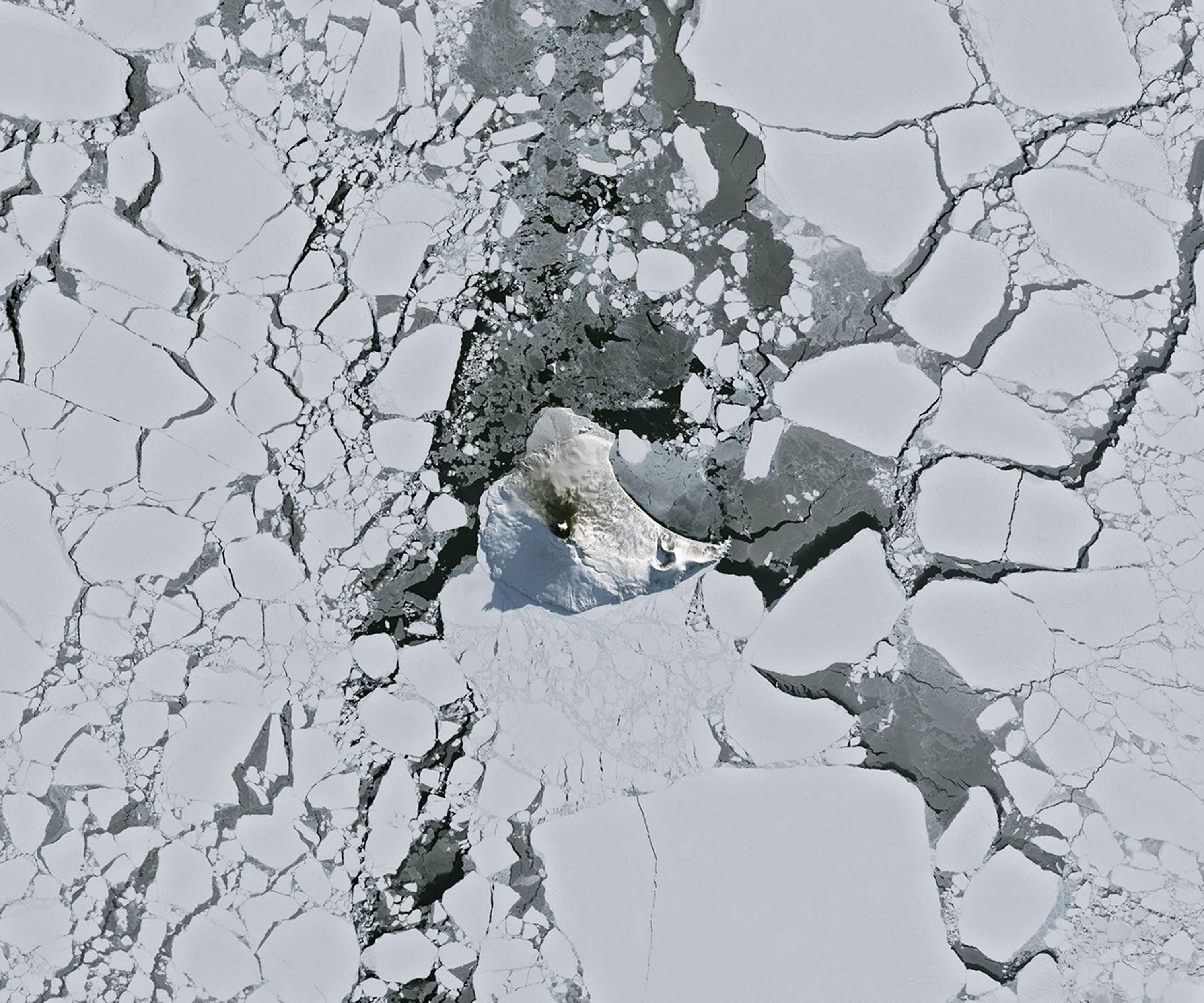
A small ice- and snow-covered island with an active volcanic crater at its center is surrounded by drifting pieces of sea ice. A thermal signal and small plume appear in the crater, and ash darkens the snow on the volcano’s northern slopes.
Mount Michael on Saunders Island, seen in this image acquired with the OLI (Operational Land Imager) on Landsat 8 on August 24, 2026, hosts a frequently active lava lake in its summit crater.
NASA Earth Observatory/Michala Garrison

Winter near the Antarctic Circle brings months of frozen darkness, when sea ice chokes ocean waters and many of its denizens hunker down to ride out the harsh conditions. But as winter began to release its icy grip, an uncommonly clear satellite image revealed that part of this remote realm was still very much awake, at least volcanically speaking.

Mount Michael, the stratovolcano at the center of Saunders Island, rises above the ice-filled South Atlantic Ocean in this image, acquired with the OLI (Operational Land Imager) on the NASA-USGS Landsat 8 satellite on August 24, 2026. The natural-color image is overlaid with an infrared signal (OLI bands 7-6-5), shown in red, revealing heat from the persistent lava lake in its summit crater. A puff of a volcanic plume hovering over the peak, along with darkened snow on its northern slopes, also suggests ongoing activity.

Saunders Island is one of the South Sandwich Islands, a string of small volcanic peaks about 350 kilometers (220 miles) long that formed from the South American plate subducting beneath the tiny South Sandwich plate. Regular eruptions, including at Mount Michael, have occurred on these islands in recent centuries.

Because of the volcanoes’ remoteness, scientists rely on satellite data to understand their activity. An analysis of thermal anomalies in Landsat, Sentinel, and ASTER (Advanced Spaceborne Thermal Emission and Reflection Radiometer) observations spanning 30 years led researchers to conclude that Mount Michael hosts a persistent lava lake in its summit crater. Only a handful of other volcanoes on Earth, including Kīlauea, Nyamulagira, and Erta Ale, are known to have similar, frequently active features.

Thermal observations from the MODIS (Moderate Resolution Imaging Spectroradiometer) and VIIRS (Visible Infrared Imaging Radiometer Suite) instruments have also enabled long-term monitoring of Mount Michael. Data provided through MIROVA, a near-real-time volcanic hot spot detection system, indicate that low-intensity activity has been ongoing at the volcano for the past several years. Other observations from NASA’s Aura satellite show that emissions of sulfur dioxide and other gases are common at Mount Michael.

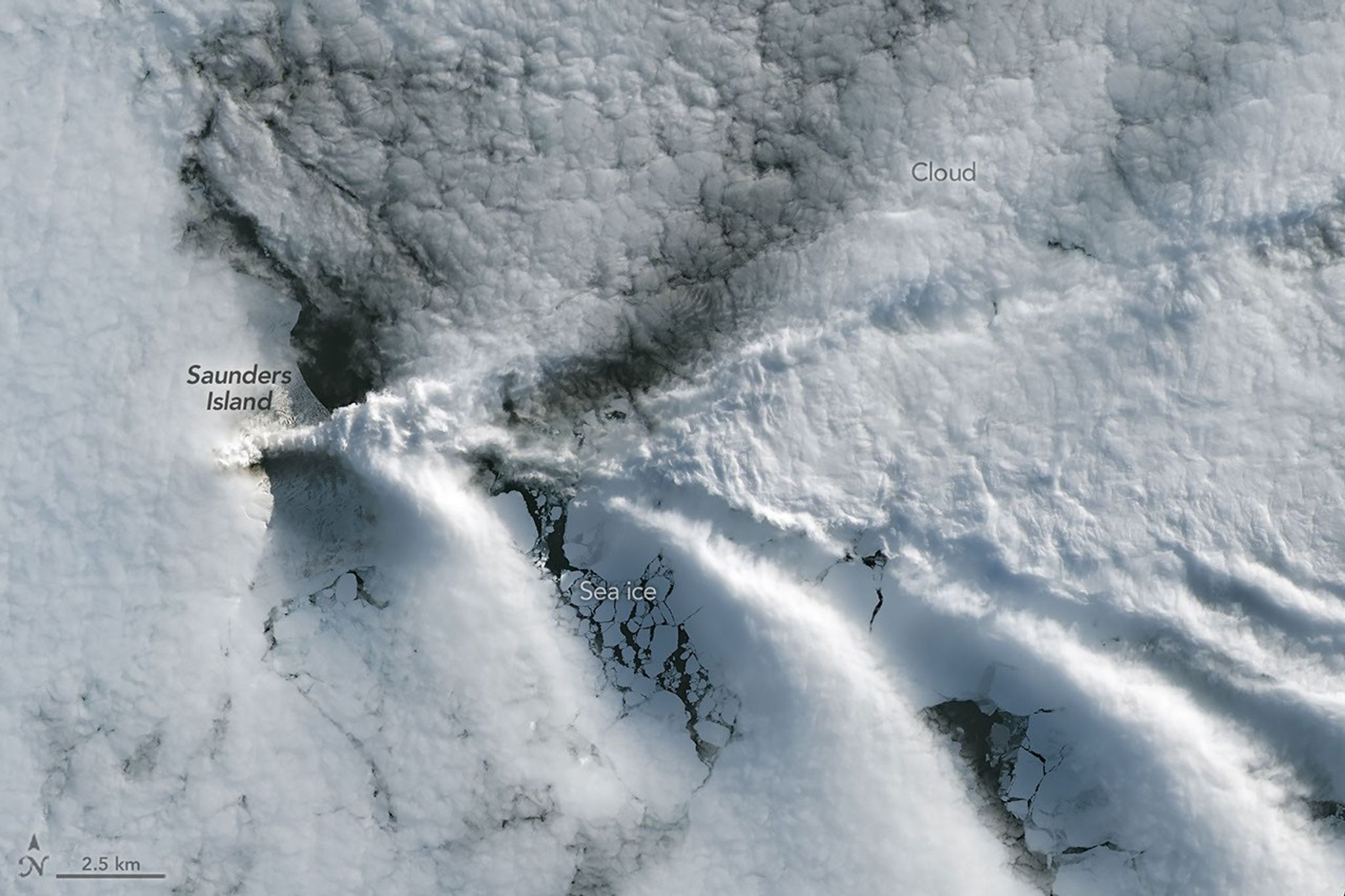
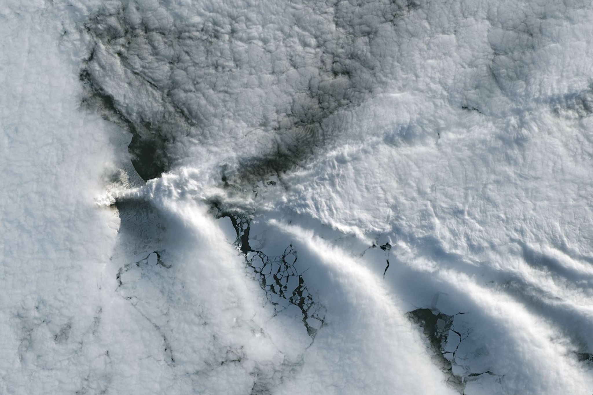
A series of V-shaped wave clouds appears over an ocean filled with pieces of sea ice.
Wave clouds form downwind of Saunders Island in this image acquired with the OLI (Operational Land Imager) on Landsat 9 on September 1, 2026.
NASA Earth Observatory/Michala Garrison

The cloud-free window over Mount Michael would close in short order. One week later, when Landsat 9 passed over the island, a more active atmosphere had returned. But the weather patterns interacted with the island to put on a spectacle of their own. The 843-meter-high (2,766-foot-high) peak jutting from the ocean disturbed passing winds to produce a series of wave clouds resembling the wake of a ship, a familiar phenomenon in this region. False-color imagery captured by NASA’s Aqua satellite indicates that a volcanic track caused by degassing sulfur dioxide was likely present as well.

NASA Earth Observatory images by Michala Garrison, using Landsat data from the U.S. Geological Survey. Story by Lindsey Doermann.

References & Resources

You may also be interested in:

Stay up-to-date with the latest content from NASA as we explore the universe and discover more about our home planet.

Ever Restless Mount Dukono Erupts

2 min read

The volcano on Indonesia’s Halmahera Island routinely ejects ash, volcanic gases, and volcanic bombs.

Article

A Sea of Spinning Clouds

3 min read

Icy, isolated Peter I Island stirred up a show in the atmosphere off the West Antarctic coast.

Article

America’s Emerald Isle

3 min read

Beaver Island is one in a string of verdant and scenic jewels in a northern Lake Michigan archipelago.

Article

Source: science.nasa.gov

Casino en ligne en France : fonctionnement, risques et précautions

Les casinos en ligne reproduisent sur Internet des jeux traditionnellement proposés dans les établissements physiques. Ils peuvent offrir des machines à sous, des jeux de cartes, de la roulette ou des parties animées en direct. Leur accessibilité ne signifie cependant pas qu’ils sont légalement autorisés dans tous les pays.

Quels jeux sont autorisés en France ?

La réglementation française distingue les casinos physiques autorisés des jeux accessibles sur Internet. En ligne, les opérateurs agréés peuvent proposer des paris sportifs, des paris hippiques et du poker.

En revanche, les machines à sous et les jeux de table de casino ne sont pas autorisés en ligne. Un site accessible depuis la France peut donc rester illégal, même lorsqu’il affiche une licence internationale.

Les risques associés aux sites non autorisés

L’utilisation d’un casino en ligne non autorisé peut exposer le joueur à plusieurs problèmes. Il peut s’agir d’un refus de paiement, d’une fermeture soudaine du compte, d’un vol de données ou d’une absence de recours efficace en cas de litige.

Les autorités françaises peuvent également demander le blocage de plateformes proposant illégalement des jeux d’argent sur le territoire.

Reconnaître les principaux signaux d’alerte

Un site doit être considéré avec prudence lorsqu’il :

  • promet des gains garantis ;
  • exerce une forte pression pour effectuer un dépôt ;
  • dissimule ses conditions de retrait ;
  • réclame des frais imprévus pour libérer des gains ;
  • ne fournit aucune information vérifiable sur son exploitant ;
  • utilise abusivement le logo d’une autorité française.

La présence d’une licence étrangère ne remplace pas l’agrément exigé en France.

Protéger son budget

Aucune méthode ne garantit un bénéfice régulier aux jeux de hasard. Le résultat dépend principalement du hasard et l’opérateur conserve généralement un avantage mathématique.

Pour réduire les risques, il faut déterminer une limite de dépenses, ne jamais emprunter pour jouer et faire des pauses régulières. Les mineurs ne doivent jamais accéder aux jeux d’argent.

Lorsqu’une personne ressent une perte de contrôle, elle peut utiliser les dispositifs d’auto-exclusion ou demander une interdiction volontaire de jeux. Demander de l’aide rapidement permet de mieux protéger sa santé et sa situation financière.